
The ORNL DAAC recently released a new Arctic-Boreal Vulnerability Experiment (ABoVE) dataset by Watts, J.D., et al. (2022):
Soil Respiration Maps for the ABoVE Domain, 2016-2017
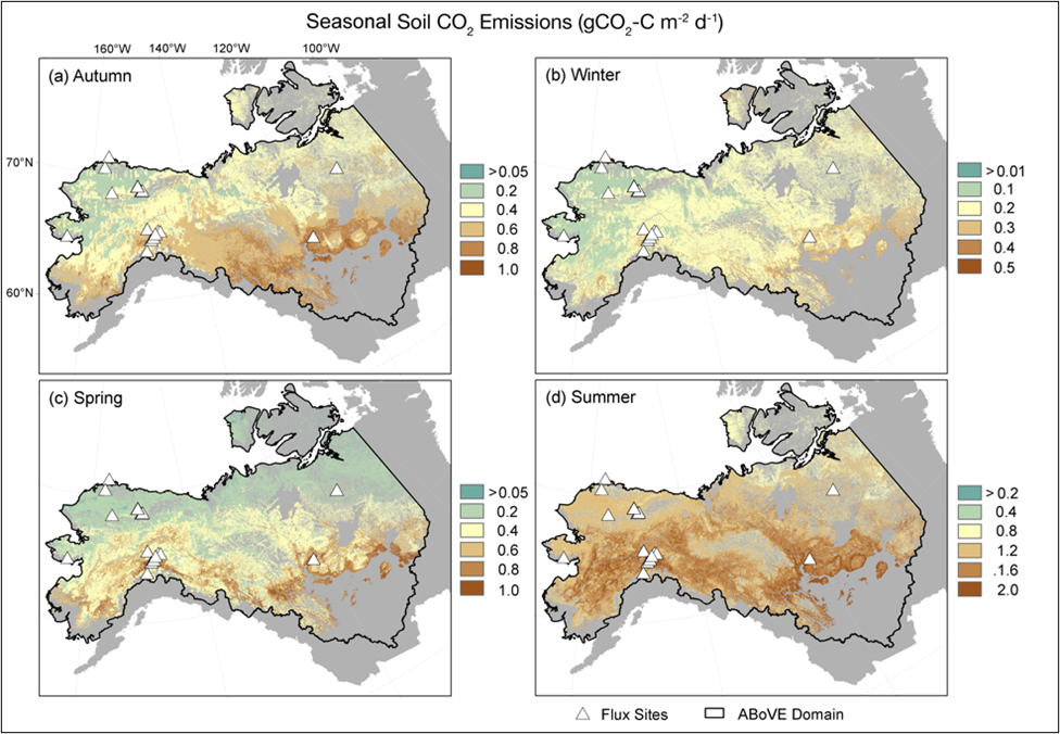
This dataset provides gridded estimates of carbon dioxide (CO2) emissions from soil respiration occurring within permafrost-affected tundra and boreal ecosystems of Alaska and Northwest Canada at a 300 m spatial resolution for the period 2016-08-18 to 2018-09-12. The estimates include monthly average CO2 flux (gCO2 C m-2 d-1), daily average CO2 flux and error estimates by season (Autumn, Winter, Spring, Summer), estimates of annual offset of CO2 uptake (i.e., vegetation GPP), annual budgets of vegetation gross primary productivity (GPP; gCO2 C m-2 yr-1), and the fraction of open (non-vegetated) water within each 300 m grid cell. Belowground sources of respiration (i.e., root and microbial) are included. The gridded soil CO2 estimates were obtained using seasonal Random Forest models, information from remote sensing, and a new compilation of in-situ soil CO2 flux from Soil Respiration Stations and eddy covariance towers. The flux tower data are provided along with daily gap-filled flux observations for each Soil Respiration station forced diffusion (FD) chamber record. The data cover the NASA ABoVE Domain.
The ABoVE is a NASA Terrestrial Ecology Program field campaign being conducted in Alaska and western Canada, for 8 to 10 years, starting in 2015. Research for ABoVE links field-based, process-level studies with geospatial data products derived from airborne and satellite sensors, providing a foundation for improving the analysis, and modeling capabilities needed to understand and predict ecosystem responses to, and societal implications of, climate change in the Arctic and Boreal regions.
Additional data from ABoVE and other relevant links can be found on the ORNL DAAC's ABoVE Project Page.
Citation: Watts, J.D., S. Natali, and C. Minions. 2022. Soil Respiration Maps for the ABoVE Domain, 2016-2017. ORNL DAAC, Oak Ridge, Tennessee, USA. https://doi.org/10.3334/ORNLDAAC/1935