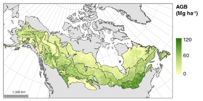
NACP LiDAR-based Biomass Estimates, Boreal Forest Biome, North America, 2005-2006
Aboveground biomass (AGB) was estimated for defined land cover types within World Wildlife Fund's (WWF) ecoregions across the boreal biome of Alaska and western and eastern Canada, roughly between 45 and 70 degrees N. The study focused on within-growing-season data, i.e., leaf-on conditions. The estimates were derived from a series of models that first related ground-based measured biomass to Portable Airborne Laser System (PALS) LiDAR measurements, and a second set of models that related the airborne estimates of biomass to Geoscience Laser Altimeter System (GLAS) LiDAR canopy structure measurements. The GLAS LiDAR biomass estimates were extrapolated by land cover types and ecoregions across the entire biome area.
To view complete documentation and access the data, visit the data set web pages at http://daac.ornl.gov/cgi-bin/dsviewer.pl?ds_id=1273
Data Acknowledgements: Data authors: Margolis, H., G. Sun, P.M. Montesano, and R.F. Nelson. Data center: ORNL DAAC (http://daac.ornl.gov) Sponsor: NASA EOSDIS (http://earthdata.nasa.gov) Data Set DOI: 10.3334/ORNLDAAC/1273


