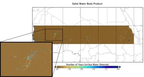
Location and Permanency of Water Bodies in the African Sahel Region from 2003-2011.
This data set provides an estimate of the spatial and temporal extent of surface water at 250-m resolution over 9 years (2003-2011) for the African Sahel region (10-20 degrees N) using imagery from MODIS. Water bodies were identified by a spectral analysis of MODIS vegetation indices with the aim to improve existing regional to global mapping products. This dataset can be used to enhance the understanding of Earth system processes, and to support global change studies, agricultural planning, and disease prevention. These data provide a gridded (250-m) estimate of the number of years (during 2003-2011) that a pixel was covered by water.
To view complete documentation and access the data, visit the data set Web page at http://daac.ornl.gov/cgi-bin/dsviewer.pl?ds_id=1269
Data Acknowledgements
- Data authors: Kaptue, A.T., N.P. Hanan, and L. Prihodko
- Data center: ORNL DAAC (http://daac.ornl.gov)
- Sponsor: NASA EOSDIS (http://earthdata.nasa.gov)
- Data Set DOI: http://dx.doi.org/10.3334/ORNLDAAC/1269