Body
A new dataset provides forest characteristics at unburned and recovering burned sites in Brazil.

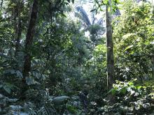
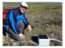
An unburned forest plot at the Transacreana site in Acre, Brazil. Data were collected in late 2017.
A new dataset provides forest characteristics at unburned and recovering burned sites in Brazil.

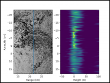
Tomographic image of Lope National Park for the cross-section marked by the blue line. Note the contrast between dark areas dominated by surface scattering and the bright areas with scattering through the forest canopy.
Three-dimensional maps of forest structure in Gabon are now available from the 2016 AfriSAR campaign.

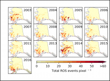
Annual time series of days with rain-on-snow summed for each 6-km pixel in Alaska.
Researchers with NASA's ABoVE campaign mapped rain-on-snow events across Alaska from 2003 to 2016.

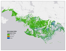
Map of tidal marsh green vegetation, non-vegetation, and open water at 1m resolution for the Mississippi River Delta site in Terrebonne and St. Mary Parishes, Louisiana.
Three new datasets from NASA's Carbon Monitoring System provide high-resolution maps of six US tidal marshes.

Oak Ridge National Lab Distinguished Researcher Peter Thornton in the field.
The lead developer of Daymet receives recognition as a highly cited author.


The Centennial Meeting of the American Geophysical Union will take place in Washington D.C.
Don't miss ORNL DAAC's posters and talks at the upcoming American Geophysical Union Meeting.

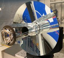
The GEDI instrument's 80 cm telescope will receive laser-light returning from Earth.
The Global Ecosystem Dynamics Investigation (GEDI) instrument will produce the first high-resolution laser ranging observations of the 3D structure of the Earth.

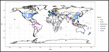
Locations of Soil Respiration Database Version 4 observations, colored by biome. Map produced by the companion SRDBv4.R script.
The Soil Respiration Database, a near-universal compendium of published soil respiration data, has been updated to version 4.0.


The interior of the instrumented NASA DC-8 aircraft as prepared for takeoff. The UHSAS data were collected during ATom deployments.
Calibration and in-flight performance data for Ultra-High Sensitivity Aerosol Spectrometers used during ATom deployments is now available.

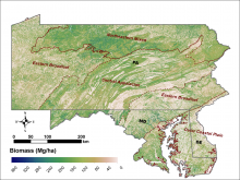
Aboveground biomass (Mg/ha) at 30-m resolution for the tri-state region of Maryland, Pennsylvania, and Delaware in 2011.
LiDAR-derived aboveground biomass, canopy height, and canopy coverage estimates for Maryland, Delaware, and Pennsylvania are now available.
