
The melting of permafrost in Arctic zones is accelerating at an alarming rate due to ongoing climate change. These changes in northern circumpolar permafrost zones threaten not only infrastructure but have the potential for releasing dangerous greenhouse gases into the air that had been otherwise trapped below ground. As global temperatures continue to rise beyond historic levels, these areas are drawing greater scrutiny and attention from climate scientists around the world.
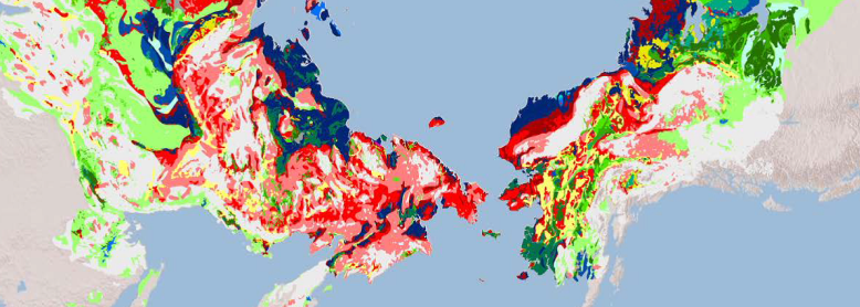
Thermokarst landscapes are an indicator of permafrost melt. Thermokarst is characterized by pitted, irregular surfaces, marshy-hollows, and lakes that form in the upheaval and depressions left by permafrost melting.
In a recent paper "Thermokarst terrain: pan-Arctic distribution and soil carbon vulnerability", investigators seek to quantify and map the results of melting permafrost, known as thermokarst landscapes. The data behind this investigation is archived at the ORNL DAAC.
Arctic Circumpolar Distribution and Soil Carbon of Thermokarst Landscapes, 2015 provides the distribution of thermokarst landscapes in boreal and tundra ecoregions within the northern circumpolar permafrost zones. Estimates of carbon storage in thermokarst landscapes are also provided.
Data Acknowledgements
Data Authors: Olefeldt, D., S. Goswami, G. Grosse, D.J. Hayes, G. Hugelius, P. Kuhry, B. Sannel, E.A.G. Schuur, and M.R. Turetsky.
Data Set DOI: http://dx.doi.org/10.3334/ORNLDAAC/1332
Data center: ORNL DAAC
Sponsor: NASA EOSDIS
