
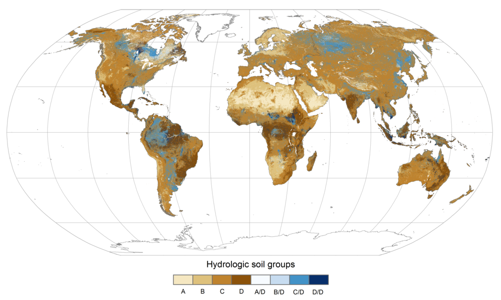
Hydrologic soil groups (HSGs) are a fundamental component of the USDA curve number (CN) method for estimation of rainfall runoff; yet these data are not readily available in a format or spatial resolution suitable for regional to global scale modeling applications. A new dataset provides a globally consistent gridded dataset defining HSGs to fill this gap.
Global Hydrologic Soil Groups (HYSOGs250m) for Curve Number-Based Runoff Modeling
This dataset provides a globally consistent set of hydrologic soil groups (HSGs) of rainfall runoff potential gridded at 250 m resolution. The HSGs were specifically developed from contemporary soil information to support continental and global scale stormwater runoff calculations using the U.S. Department of Agriculture (USDA) curve number (CN) method. CN-based runoff estimates require information regarding the minimum infiltration and transmission rate of rainfall through the soil profile after prolonged wetting. Soils were classified into four HSGs using Food and Agriculture Organization (FAO) soilGrids250m system texture class and bedrock depth predictions to infer runoff potential. This dataset supports continental and global scale CN-based runoff modeling.
Data Citation:
Ross, C.W., L. Prihodko, J. Anchang, S. Kumar, W. Ji, and N.P. Hanan. 2018. Global Hydrologic Soil Groups (HYSOGs250m) for Curve Number-Based Runoff Modeling. ORNL DAAC, Oak Ridge, Tennessee, USA. https://doi.org/10.3334/ORNLDAAC/1566
Data center: ORNL DAAC
Sponsor: NASA EOSDIS
