
Soil Moisture Profiles and Temperature Data from SoilSCAPE Sites, USA
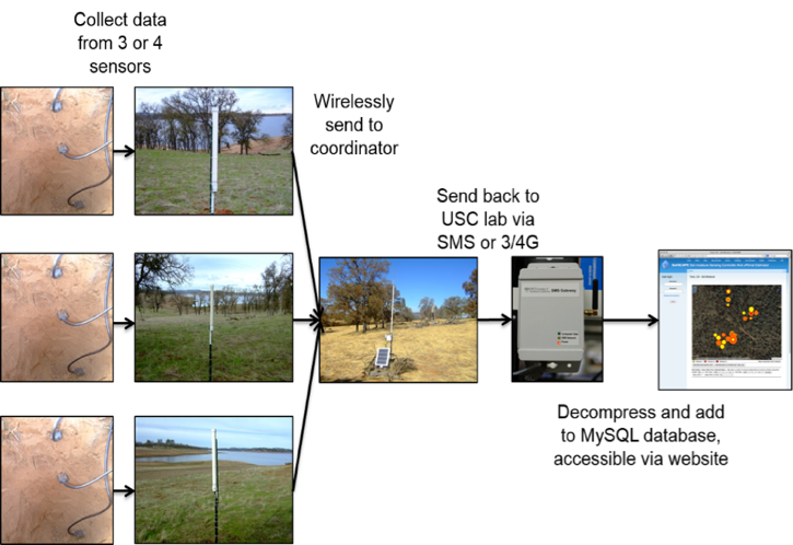
This data set contains in-situ soil moisture profile and soil temperature data collected at 20-minute intervals at SoilSCAPE (Soil moisture Sensing Controller and oPtimal Estimator) project sites in four states (California, Arizona, Oklahoma, and Michigan) in the United States. SoilSCAPE used wireless sensor technology to acquire high temporal resolution soil moisture and temperature data at up to 12 sites over varying durations since August 2011. At its maximum, the network consisted of over 200 wireless sensor installations (nodes), with a range of 6 to 27 nodes per site. The soil moisture sensors (EC-5 and 5-TM from Decagon Devices) were installed at three to four depths, nominally at 5, 20, and 50 cm below the surface. Soil conditions (e.g., hard soil or rocks) may have limited sensor placement. Temperature sensors were installed at 5 cm depth at six of the sites. Data collection started in August 2011 and continues at eight sites through late 2016. The data enables estimation of local-scale soil moisture at high temporal resolution and validation of remote sensing estimates of soil moisture at regional (airborne, e.g. NASA's Airborne Microwave Observation of Subcanopy and Subsurface Mission - AirMOSS) and national (spaceborne, e.g. NASA's Soil Moisture Active Passive - SMAP) scales.
Data Acknowledgements
Data Authors: Moghaddam, M., A.R. Silva, D. Clewley, R. Akbar, S.A. Hussaini, J. Whitcomb, R. Devarakonda, R. Shrestha, R.B. Cook, G. Prakash, S.K. Santhana Vannan, and A.G. Boyer.
Data Set DOI: http://dx.doi.org/10.3334/ORNLDAAC/1339
Data Center: ORNL DAAC
Sponsor: NASA EOSDIS
