
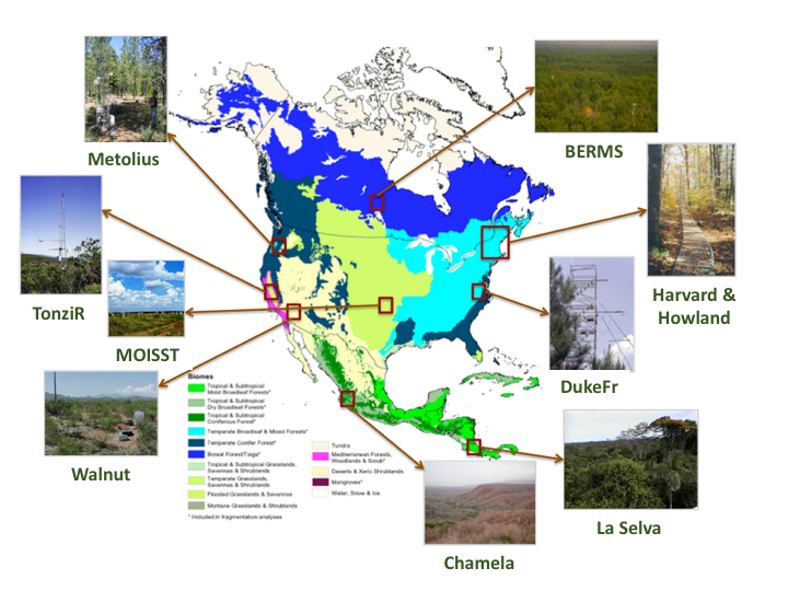
Ten AirMOSS data sets provide level 1 (L1) polarimetric radar backscattering coefficient (sigma-0), multilook complex, polarimetrically calibrated, and georeferenced data products from the Airborne Microwave Observatory of Subcanopy and Subsurface (AirMOSS) radar instrument. The data are organized by the ten different AirMOSS sites:
-
AirMOSS: L1 S-0 Polarimetric Data from AirMOSS P-band SAR, BERMS, Canada, 2012-2015
AirMOSS: L1 S-0 Polarimetric Data from AirMOSS P-band SAR, Chamela, Mexico, 2012-2015
AirMOSS: L1 S-0 Polarimetric Data from AirMOSS P-band SAR, Duke Forest, 2012-2015
AirMOSS: L1 S-0 Polarimetric Data from AirMOSS P-band SAR, Harvard Forest, 2012-2015
AirMOSS: L1 S-0 Polarimetric Data from AirMOSS P-band SAR, Howland Forest, 2012-2015
AirMOSS: L1 S-0 Polarimetric Data from AirMOSS P-band SAR, La Selva, 2012-2015
AirMOSS: L1 S-0 Polarimetric Data from AirMOSS P-band SAR, Metolius, 2012-2015
AirMOSS: L1 S-0 Polarimetric Data from AirMOSS P-band SAR, MOISST, 2012-2015
AirMOSS: L1 S-0 Polarimetric Data from AirMOSS P-band SAR, Tonzi Ranch, 2012-2015
AirMOSS: L1 S-0 Polarimetric Data from AirMOSS P-band SAR, Walnut Gulch, 2012-2015
The AirMOSS radar is a P-band (UHF) fully polarimetric synthetic aperture radar (SAR) currently operating in the 420-440 MHz band designed to measure root-zone soil moisture (RZSM) and is flown on a NASA Gulfstream-III aircraft. Flight campaigns took place at least biannually from 2012 to 2015 at 10 study sites across North America. The acquired L1 P-band radar backscatter data will be used to retrieve the RZSM at the study sites. Subsequent analyses will investigate both seasonal and inter-annual variability in soil moisture and the relationships to carbon fluxes and their associated uncertainties on a continental scale.
Data Acknowledgements:
Data Authors: AirMOSS Science Team
Data center: ORNL DAAC
Sponsor: NASA EOSDIS
