
The ORNL DAAC recently released a new SBG High Frequency Time Series (SHIFT) dataset from Brodrick, P. et al. (2023):
SHIFT: AVIRIS-NG L2A Unrectified Reflectance
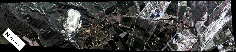
This dataset contains Level 2A (L2A) unrectified surface reflectance images from NASA's Airborne Visible / Infrared Imaging Spectrometer-Next Generation (AVIRIS-NG) instrument. This imagery was collected as part of the Surface Biology and Geology High-Frequency Time Series (SHIFT) campaign which occurred during February to May, 2022, with a follow up activity for one week in September. The SHIFT campaign leveraged NASA's AVIRIS-NG facility instrument to collect approximately weekly VSWIR imagery across the study area enabling traceability analyses related to the science value of VSWIR revisit without relying on multispectral proxies. This campaign will generate precise, high-frequency data on plant communities collected over nearly 1,656 square kilometers across Santa Barbara County, California, US, and nearby coastal Pacific waters. AVIRIS-NG is a pushbroom spectral mapping system with high signal-to-noise ratio (SNR), designed and toleranced for high performance spectroscopy. AVIRIS-NG measures reflected radiance at 5-nm intervals in the Visible to Shortwave Infrared (VSWIR) spectral range from 380-2510 nm. The AVIRIS-NG sensor has a 1 milliradian instantaneous field of view, providing altitude dependent ground sampling distances from 20 m to sub-meter range. The AVIRIS-NG L2A data are provided in ENVI binary format, which includes a flat binary file accompanied by a header (.hdr) file holding metadata in text format.
The Surface Biology and Geology (SBG) High Frequency Time Series (SHIFT) was an airborne and field campaign during February to May, 2022, with a follow up activity for one week in September, in support of NASA's SBG mission. Its study area included a 640-square-mile (1,656-square-kilometer) area in Santa Barbara County and the coastal Pacific waters. The primary goal of the SHIFT campaign was to collect a repeated dense time series of airborne Visible to ShortWave Infrared (VSWIR) airborne imaging spectroscopy data with coincident field measurements in both inland terrestrial and coastal aquatic areas, supported in part by a broad team of research collaborators at academic institutions. The SHIFT campaign leveraged NASA's Airborne Visible-Infrared Imaging Spectrometer-Next Generation (AVIRIS-NG) facility instrument to collect approximately weekly VSWIR imagery across the study area. The SHIFT campaign 1) enables the NASA SBG team to conduct traceability analyses related to the science value of VSWIR revisit without relying on multispectral proxies, 2) enables testing algorithms for consistent performance over seasonal time scales and end-to-end workflows including community distribution, and 3) provides early adoption test cases to SHIFT application users and incubate relationships with basic and applied science partners at the University of California Santa Barbara Sedgwick Reserve and The Nature Conservancy's Jack and Laura Dangermond Preserve.
Additional data from SHIFT and other relevant links can be found on the ORNL DAAC's SHIFT Project Page.
Citation: Brodrick, P., R. Pavlick, M. Bernas, J.W. Chapman, R. Eckert, M. Helmlinger, M. Hess-Flores, L.M. Rios, F.D. Schneider, M.M. Smyth, M. Eastwood, R.O. Green, D.R. Thompson, K.D. Chadwick, and D.S. Schimel. 2023. SHIFT: AVIRIS-NG L2A Unrectified Reflectance. ORNL DAAC, Oak Ridge, Tennessee, USA. https://doi.org/10.3334/ORNLDAAC/2183