
CARVE: L4 Gridded Footprints from WRF-STILT model, 2012-2016
This data set provides Weather Research and Forecasting (WRF) Stochastic Time-Inverted Lagrangian Transport (STILT) Footprint data products for particle receptors located at positions along Carbon in Arctic Reservoirs Vulnerability Experiment (CARVE) flight paths (2012 - 2015) and various meteorological stations in Alaska and the Canadian Arctic. Each product consists of multiple NetCDF footprint files packaged as a TAR/GZIP file. These aircraft and station positions were treated as receptors in the WRF-STILT model in order to simulate the land surface influence on observed atmospheric constituents. The measurements included in this data set are crucial for understanding changes in Arctic carbon cycling and the potential threats posed by thawing of Arctic permafrost.
CARVE: L4 Gridded Particle Trajectories for WRF-STILT model, 2012-2016
These particle files support the CARVE: L4 Gridded Footprints from WRF-STILT model. The relationship between particle files and footprint files is outlined in the companion file 'carve_wrf-stilt_inventory.csv'.
Data Acknowledgements
Data authors: CARVE Science Team
Data Set DOIs: http://dx.doi.org/10.3334/ORNLDAAC/1431 and http://dx.doi.org/10.3334/ORNLDAAC/1430
Data center: ORNL DAAC
Sponsor: NASA EOSDIS
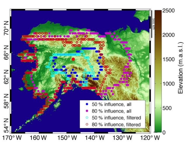
 for the average WRF-STILT influence functions (mid-afternoon averages 2012-2014) show CO2 and CH4 measurements from the CARVE tower have a high sensitivity to the boreal forests and lowlands of interior Alaska. Cyan and red circles are shown for the footprints after filtering (from Karion et al., 2016).")