
The ORNL DAAC recently released a new Arctic-Boreal Vulnerability Experiment (ABoVE) dataset by Potter, S., et al. (2022):
ABoVE: Burned Area, Depth, and Combustion for Alaska and Canada, 2001-2019
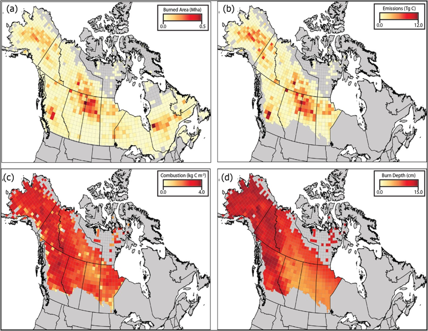
This dataset provides annual gridded estimates of fire locations and associated burn fraction per pixel for Alaska and Canada at approximately 500 m spatial resolution for the period 2001-2019. Gridded predictions of carbon combustion and burn depth for the same period within the ABoVE extended domain using the burn area maps and field data are also available. Fire locations and date of burn (DOB) were detected by MODIS-derived active fire products. Burned area was primarily estimated from finer-scale Landsat imagery using a differenced Normalized Burn Ratio (dNBR) algorithm and upscaled to an approximate 500 m MODIS resolution. Aboveground combustion, belowground combustion, and burn depth were statistically modeled at the pixel level for every mapped burned pixel in the ABoVE extended domain based on field observations across Alaska and western Canada. Predictor variables included remotely sensed indicators of fire severity, topography, soils, climate, and fire weather. Quality flags for burned area and combustion are available. Fire is the dominant disturbance agent in Alaskan and Canadian boreal ecosystems and releases large amounts of carbon into the atmosphere. These data are useful for studies of disturbance, fire ecology, and carbon cycling in boreal ecosystems.
The ABoVE is a NASA Terrestrial Ecology Program field campaign being conducted in Alaska and western Canada, for 8 to 10 years, starting in 2015. Research for ABoVE links field-based, process-level studies with geospatial data products derived from airborne and satellite sensors, providing a foundation for improving the analysis, and modeling capabilities needed to understand and predict ecosystem responses to, and societal implications of, climate change in the Arctic and Boreal regions.
Additional data from ABoVE and other relevant links can be found on the ORNL DAAC's ABoVE Project Page.
Citation: Potter, S., S. Veraverbeke, X.J. Walker, M.C. Mack, S.J. Goetz, J.L. Baltzer, C. Dieleman, N.H.F. French, E.S. Kane, M.R. Turetsky, E.B. Wiggins, and B.M. Rogers. 2022. ABoVE: Burned Area, Depth, and Combustion for Alaska and Canada, 2001-2019. ORNL DAAC, Oak Ridge, Tennessee, USA. https://doi.org/10.3334/ORNLDAAC/2063