Body
Lab-measured soil properties, including soil water matric potential, soil dielectric properties, soil electrical conductivity, corresponding soil moisture.

Site locations. (a) in Northern Slope Alaska. (b) Central region of Alaska.
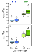
Ratios of (a) maximum rate of carboxylation to respiration at 25 degrees C from Griffin et al. (2022) (Vcmax /R25 ) and (b) maximum electron transport rate to respiration at 25 degrees C from Griffin et al. (2022) (Jmax /R25 ) of white spruce from high and low canopy positions at the Forest Tundra Ecotone (FTE, blue), Alaska, and Black Rock Forest (BRF, green), New York. Boxplots show the median and first and third quartiles. Whiskers display the range of groups with individual points representing outliers falling outside 1.5 times the interquartile range. Different letters represent significant differences between locations and canopy positions.
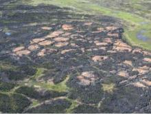
The 2007 Anaktuvuk River fire burned across riparian stringers and wet channels around high-centered polygons that are typically left as unburned inclusions. (2008 photo by D. Yokel). Source: Jandt et al., 2012.
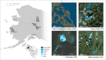
Four subregions of Alaska (left) with example of lakes and ponds derived from PlanetScope imagery (right). Lake and pond extents include monthly climatological composites (May - September) and 3-year composites for 2019-2021. The inset for the Fairbanks (FB) region shows a close-up of the water extents overlain on sub-meter Esri base map imagery. The Yukon Flats (YF) inset shows variability in surface area of large lakes. The Delta Junction (DJ) inset shows seasonal changes in the area of small ponds. The Yukon-Kuskokwim Delta (YKD) inset shows the spatial variability of water body areas in this region and is an example of a 3-year composite.
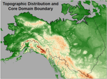
The topographic distribution and core domain boundary of the ABoVE study area (image is from Liston and Reinking, 2022).
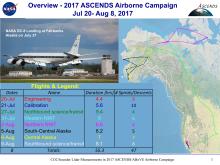
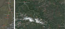
A map showing the ground tracks for the airborne campaign with a table summarizing each flight. The colors in the table match those shown in the ground tracks. Image is from the related dataset Abshire et al. (2022).
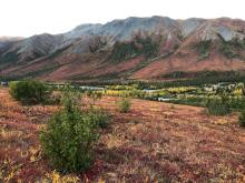
Alder shrubs expanding into graminoid tundra. Coldfoot Valley, Alaska. 2019.
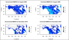
Two examples of uncorrected and corrected months Canada-Alaska domain. The correction is applied to pixels > 500 m, so the correction is seen primarily in mountainous areas. Figure from Lober et al. (in review).
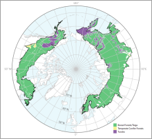
Tree canopy cover over global boreal forests in 2020.
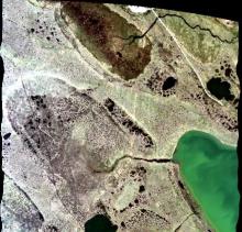
A portion of the quicklook image from flight line ang20170714t212855 over Barrow, Alaska on July 14, 2017. Two sites (AB_B10_L001_FL175_PipelineLake and AB_B10_L003_FL175_PipelineLake) of interest to the ABoVE project are visible. Flight altitude was approximately 5,400 m with very thin cirrus cloud cover.