
The ORNL DAAC recently released a new Arctic-Boreal Vulnerability Experiment (ABoVE) dataset by Mullen, A., et al. (2022):
ABoVE: Lake and Pond Extents in Alaskan Boreal and Tundra Subregions, 2019-2021
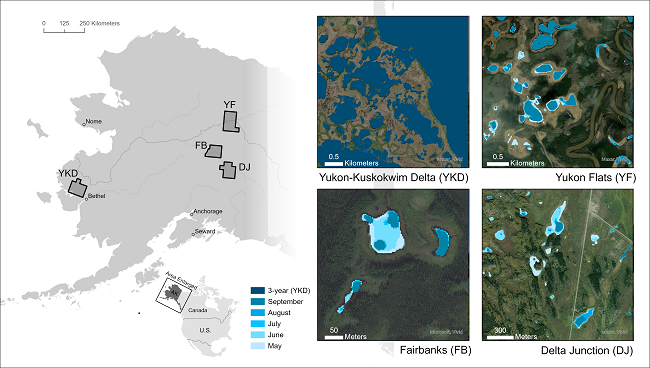
This dataset provides polygon spatial files of lake and pond extents for three sub-regions of Interior Alaska's boreal forest, and one tundra region located in Alaska's Yukon-Kuskokwim Delta. Files provide lake and pond extents of standing water without wetland vegetation or other obstructions with a minimum area of 0.01 ha. Water extents were derived from Planet Labs PlanetScope imagery with resolution of 3.125 m. A deep learning model (U-Net) was applied to PlanetScope orthotile imagery from Planet Labs' Dove-R and Super Dove satellites. The U-Net model used the red, green, blue, and near-infrared bands along with a slope raster derived from a 30-m digital elevation model (DEM) as inputs. The U-Net detected water bodies in all available cloud-free images from the snow-free period (May-September) of 2019-2021. Water body data are provided as 3-year composites (2019-2021) for all four regions and monthly climatological composites (May-September) over 2019-2021 for the three boreal forest regions. The composite water files indicate the presence of open, standing water in >40% of valid PlanetScope observations for a given composite time-slice. Files are provided in shapefile format.
The ABoVE is a NASA Terrestrial Ecology Program field campaign being conducted in Alaska and western Canada, for 8 to 10 years, starting in 2015. Research for ABoVE links field-based, process-level studies with geospatial data products derived from airborne and satellite sensors, providing a foundation for improving the analysis, and modeling capabilities needed to understand and predict ecosystem responses to, and societal implications of, climate change in the Arctic and Boreal regions.
Additional data from ABoVE and other relevant links can be found on the ORNL DAAC's ABoVE Project Page.
Citation: Mullen, A., J.D. Watts, B.M. Rogers, M.L. Carroll, J.A. Caraballo-Vega, J. Noomah, Z.W. Williams, J.K.Y. Hung, and S. Natali. 2022. ABoVE: Lake and Pond Extents in Alaskan Boreal and Tundra Subregions, 2019-2021. ORNL DAAC, Oak Ridge, Tennessee, USA. https://doi.org/10.3334/ORNLDAAC/2134