
The ORNL DAAC recently released a new Arctic-Boreal Vulnerability Experiment (ABoVE) dataset by French, N.H.F., et al. (2022):
ABoVE: Wetland Type, Slave River and Peace-Athabasca Deltas, Canada, 2007 and 2017
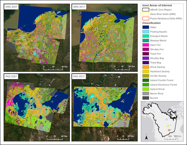
This dataset provides ecosystem-types for the Slave River Delta (SRD) and Peace-Athabasca Delta (PAD), Canada, for the time periods circa 2007 and circa 2017. The image resolution is 12.5 m with 0.2-hectare minimum mapping unit. Included are an 18-class modified Enhanced Wetland Classification (EWC) scheme for wetland, peatland, and upland areas. Classes were derived from a Random Forest classification trained on multi-seasonal moderate-resolution images and synthetic aperture radar (SAR) imagery sourced from aerial and satellite sensors, field data, and calculated indices. Indices included Height Above Nearest Drainage (HAND) and Topographic Position Index (TPI), both derived from a digital elevation model, to differentiate between land cover types. The c. 2007 remote sensing data were comprised of early and late growing season Landsat-5, ERS2, L-Band PALSAR from 2006 to 2010 and growing season Landsat thermal composites. The c. 2017 remote sensing data were comprised of early and late growing season Landsat-8 and L-Band PALSAR-2 from 2017 to 2019, Sentinel-1 June VV and VH mean and standard deviations, and growing season Landsat thermal composites. Elevation indices from multi-resolution TPI and HAND were created from the Japan Aerospace Exploration Agency Advanced Land Observing Satellite 30 m Global Spatial Data Model. Also included are the images used for classification and the classification error matrices for each map and time period. Data are provided in GeoTIFF and GeoPackage file formats.
The ABoVE is a NASA Terrestrial Ecology Program field campaign being conducted in Alaska and western Canada, for 8 to 10 years, starting in 2015. Research for ABoVE links field-based, process-level studies with geospatial data products derived from airborne and satellite sensors, providing a foundation for improving the analysis, and modeling capabilities needed to understand and predict ecosystem responses to, and societal implications of, climate change in the Arctic and Boreal regions.
Additional data from ABoVE and other relevant links can be found on the ORNL DAAC's ABoVE Project Page.
Citation: French, N.H.F., J.A. Graham, D.J.L. Vander Bilt, L.K. Jenkins, M.J. Battaglia, and L.L. Bourgeau-Chavez. 2022. ABoVE: Wetland Type, Slave River and Peace-Athabasca Deltas, Canada, 2007 and 2017. ORNL DAAC, Oak Ridge, Tennessee, USA. https://doi.org/10.3334/ORNLDAAC/1947