
Pre-ABoVE: Ground-penetrating Radar Measurements of ALT on the Alaska North Slope
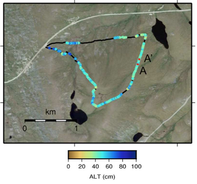
This data set includes estimates of permafrost Active Layer Thickness (ALT; cm), and calculated uncertainties, derived using a ground-penetrating radar (GPR) system in the field in August 2014 near Toolik Lake and Happy Valley on the North Slope of Alaska. GPR measurements were taken along 10 transects of varying length (approx. 1 to 7 km). Traditional ALT estimates from mechanical probing every 100 to 500 m along each transect are also included. These data are suitable for future studies of how ALT varies over relatively large geological features, such as hills and valleys, wetland areas, and drained lake basins.
Arctic-Boreal Vulnerability Experiment: The Arctic-Boreal Vulnerability Experiment (ABoVE) is a NASA Terrestrial Ecology Program field campaign that will take place in Alaska and western Canada between 2016 and 2021. Climate change in the Arctic and Boreal region is unfolding faster than anywhere else on Earth. ABoVE seeks a better understanding of the vulnerability and resilience of ecosystems and society to this changing environment.
Data Acknowledgements
Data authors: Chen, A., A. Parsekian, K. Schaefer, E. Jafarov, S.K. Panda, L. Liu, T. Zhang, and H.A. Zebker
Data set DOI: http://dx.doi.org/10.3334/ORNLDAAC/1265
Data center: ORNL DAAC
Sponsor: NASA EOSDIS
