
The ORNL DAAC recently released the following Delta-X dataset by Denbina, M.W., et al. (2023):
Delta-X: AirSWOT L2 Geocoded Water Surface Elevation, MRD, Louisiana, 2021, Version 2
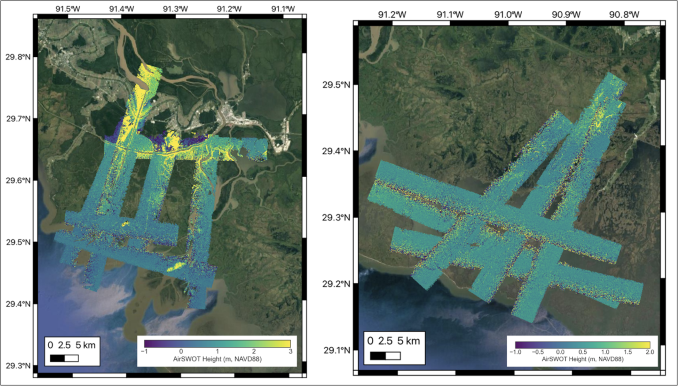
This dataset contains Level 2 (L2) AirSWOT geocoded products, including estimated water surface elevation. The AirSWOT instrument is a Ka-band interferometer and for this study is flown on the King Air B200 platform. Data were collected during the DeltaX airborne campaign over the Atchafalaya and Terrebonne basins of the Mississippi River Delta, Louisiana, USA. Flights occurred during the Delta-X Spring 2021 deployment from 2021-03-26 to 2021-04-18 and the Delta-X Fall 2021 deployment from 2021-08-21 to 2021-09-12. AirSWOT is capable of producing high resolution (3.6 m) digital elevation models over land and water bodies using near-nadir wide-swath Ka-band radar interferometry to measure water-surface elevation and produce continuous gridded elevation data. The instrument includes six antennas that form multiple baseline pairs for along-track and across-track interferometry. AirSWOT elevation data is useful for calibrating elevation and slopes along the main channels, as well as tying observations to open ocean tidal conditions and is an airborne calibration and validation instrument for the Surface Water and Ocean Topography (SWOT) satellite. In this Version 2, datafiles from the Delta-X Spring 2021 Campaign released in Version 1 were reprocessed using an improved calibration. This version also contains the initial release of data from the Delta-X Fall 2021 Campaign. Note that data acquired on September 1 and September 5, 2021 do not meet the expected MAE in-situ comparison and should be used with caution. This AirSWOT Level 2 dataset contains Cloud Optimized GeoTIFF rasters in UTM map coordinates for each flight line. In addition, a text file provides basic metadata, including flight line ID, start and end UTC times of data acquisition, processor version number, and the date and time of different processing stages.
Delta-X is a 5-year NASA Earth Ventures Suborbital-3 mission to study the Mississippi River Delta in the United States, which is growing and sinking in different areas. River deltas and their wetlands are drowning as a result of sea level rise and reduced sediment inputs. The Delta-X mission will determine which parts will survive and continue to grow, and which parts will be lost. Delta-X begins with airborne and in situ data acquisition and carries through data analysis, model integration, and validation to predict the extent and spatial patterns of future deltaic land loss or gain.
Additional data from the Delta-X project can be found on the Delta-X Project page.
Citation: Denbina, M.W., M. Simard, and E. Rodriguez. 2023. Delta-X: AirSWOT L2 Geocoded Water Surface Elevation, MRD, Louisiana, 2021, Version 2. ORNL DAAC, Oak Ridge, Tennessee, USA. https://doi.org/10.3334/ORNLDAAC/2128