Body
AVIRIS-NG Bidirectional Reflectance Distribution Function (BRDF) and sunglint-corrected surface spectral reflectance images over the Mississippi River Delta. V2 contains corrected files with missing data.

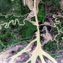
A BRDF and sunglint-corrected image of the Atchafalaya basin.
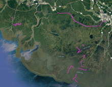
Map of boat survey areas during the Fall 2021 Delta-X campaign.
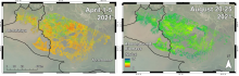
Herbaceous aboveground biomass (megagrams/hectare) product for the Atchafalaya and Terrebonne Basins, coastal Louisiana, derived from AVIRIS-NG data collected during the April and August 2021.
Suspended and bed sediment sampling locations in the Wax Lake Delta, Louisiana. Clusters of measurements are grouped together into single points on this map. Map excludes measurements made far upstream of the Wax Lake Delta or in the Terrebonne River Basin.
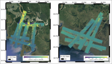
AirSWOT L2 geocoded UTM height maps collected on April 1, 2021 over the Atchafalaya Basin (left), and April 5, 2021 over the Western Terrebonne basin (right).
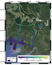
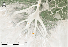
AirSWOT L3 water surface elevations collected on April 1, 2021 over the Atchafalaya Basin. Each point is colored based on its elevation with respect to the NAVD88 vertical datum (GEOID12B), as shown in the colorbar.
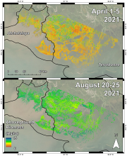
Herbaceous aboveground biomass (megagrams/hectare) product for the Atchafalaya and Terrebonne Basins derived from AVIRIS-NG data collected during the April and August 2021 campaigns.
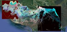
RGB composite image of the Atchafalaya and Terrebonne basins (R=Bathymetry, G=NIR of 1st quarter, B=NIR of 3rd quarter) highlighting the various ecological and geomorphological features of the landscape.
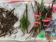
Aboveground vegetation sorted by species into biomass and necromass components.
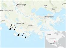
Locations of river discharge measurements (black triangles) in the Atchafalaya and Terrebonne Basins within the Mississippi River Delta (MRD) floodplain in coastal Louisiana, U.S. Measurements were taken by Delta-X project in March and April 2021.