
Monitoring the Earth's surface at high spectral resolution can advance our understanding of changing ecosystems.
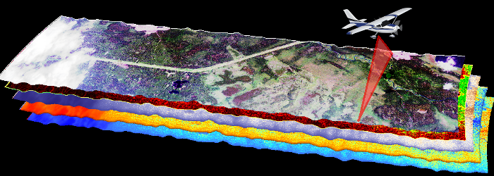
Between June and August of 2017, numerous flights were conducted over the Alaskan and Canadian Arctic as part of the Arctic-Boreal Vulnerability Experiment (ABoVE) Summer 2017 airborne campaign. One of the instruments flown, the Airborne Visible/Infrared Imaging Spectrometer-Next Generation (AVIRIS-NG) instrument, measured surface reflectance. Spectra measured by AVIRIS-NG are used to identify, measure, and monitor constituents of the Earth's surface and atmosphere. Ecological applications include species composition, structure, and function; chlorophyll, leaf water, lignin, cellulose, pigment, and non-photosynthetic constituent content.
Data from this campaign are presented in a new dataset at the ORNL DAAC:
ABoVE: Hyperspectral Imagery from AVIRIS-NG for Alaskan and Canadian Arctic, 2017
This dataset provides Level 1 radiance and Level 2 surface reflectance measured by the Airborne Visible/Infrared Imaging Spectrometer-Next Generation (AVIRIS-NG) instrument during flights over the Arctic-Boreal Vulnerability Experiment (ABoVE) domain between June and August 2017. AVIRIS-NG measures reflected radiance at 5-nanometer (nm) intervals in the visible to shortwave infrared spectral range between 380 and 2510 nm. Measurements are radiometrically and geometrically calibrated and provided at approximately 5-meter spatial resolution. The data include 422 flight lines covering areas of interest to the ABoVE campaign over much of Alaska and western Canada. These data will allow researchers to characterize ecosystem structure and function near the height of the growing season. This dataset represents one part of a multisensor airborne sampling campaign conducted by eleven different aircraft teams for ABoVE.
Data Citation:
Miller, C.E., R.O. Green, D.R. Thompson, A.K. Thorpe, M. Eastwood, I.B. Mccubbin, W. Olson-Duvall, M. Bernas, C.M. Sarture, S. Nolte, L.M. Rios, M.A. Hernandez, B.D. Bue, and S.R. Lundeen. 2018. ABoVE: Hyperspectral Imagery from AVIRIS-NG for Alaskan and Canadian Arctic, 2017. ORNL DAAC, Oak Ridge, Tennessee, USA. https://doi.org/10.3334/ORNLDAAC/1569
See all data from the ABoVE campaign: https://daac.ornl.gov/cgi-bin/dataset_lister.pl?p=34.

