
The ORNL DAAC recently released a new dataset from the Carbon Monitoring System (CMS) project by
SIF and Vegetation Indices in the US Midwestern Agroecosystems, 2016-2021
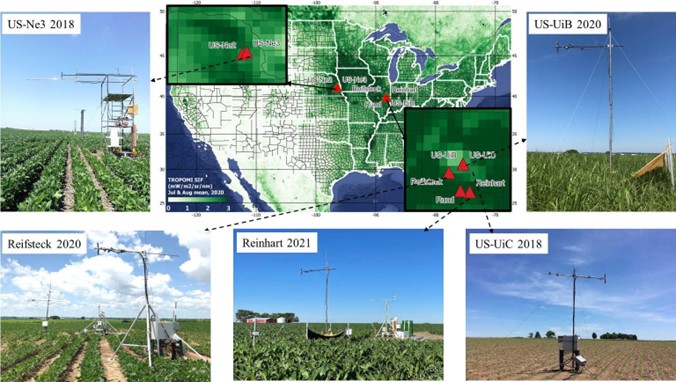
This dataset contains half-hourly ground solar-induced chlorophyll fluorescence (SIF) and vegetation indices including NDVI, EVI, Red edge chlorophyll index, green chlorophyll index, and photochemical reflectance index at seven crop sites in Nebraska and Illinois for the period 2016-2021. Four sites were located at Eddy Covariance (EC) tower sites (sites US-Ne2, US-Ne3, US-UiB, and US-UiC), and three sites were located on private farms (sites Reifsteck, Rund, and Reinhart). The sites were either miscanthus, corn-soybean rotation or corn-corn-soybean rotation. The spectral data for SIF retrieval and hyperspectral reflectance for vegetation index calculation were collected by the FluoSpec2 system, installed near planting, and uninstalled after harvest to collect whole growing-season data. Raw nadir SIF at 760 nm from different algorithms (sFLD, 3FLD, iFLD, SFM) are included. SFM_nonlinear and SFM_linear represent the Spectral fitting method (SFM) with the assumption that fluorescence and reflectance change with wavelength non-linearly and linearly, respectively. Additional data include two SIF correction factors including calibration coefficient adjustment factor (f_cal_corr_QEPRO) and upscaling nadir SIF to eddy covariance footprint factor (ratio_EC footprint, SIF pixel), and measured FPAR from quantum sensors and Rededge NDVI calculated FPAR. The data are provided in comma-separated values (CSV) format.
The NASA CMS program is designed to make significant contributions in characterizing, quantifying, understanding, and predicting the evolution of global carbon sources and sinks through improved monitoring of carbon stocks and fluxes. The System uses NASA satellite observations and modeling/analysis capabilities to establish the accuracy, quantitative uncertainties, and utility of products for supporting national and international policy, regulatory, and management activities. CMS data products are designed to inform near-term policy development and planning.
Additional data from Carbon Monitoring System (CMS) project and other relevant links can be found on the ORNL DAAC's CMS Project Page.
Citation: Wu, G., K. Guan, H. Kimm, G. Miao, and C. Jiang. 2023. SIF and Vegetation Indices in the US Midwestern Agroecosystems, 2016-2021. ORNL DAAC, Oak Ridge, Tennessee, USA. https://doi.org/10.3334/ORNLDAAC/2136