
The ORNL DAAC recently released the following ACT-America dataset by Pal, S., et al (2021):
ACT-America: CPL-derived Atmospheric Boundary Layer Top Height, Eastern US, 2016-2018
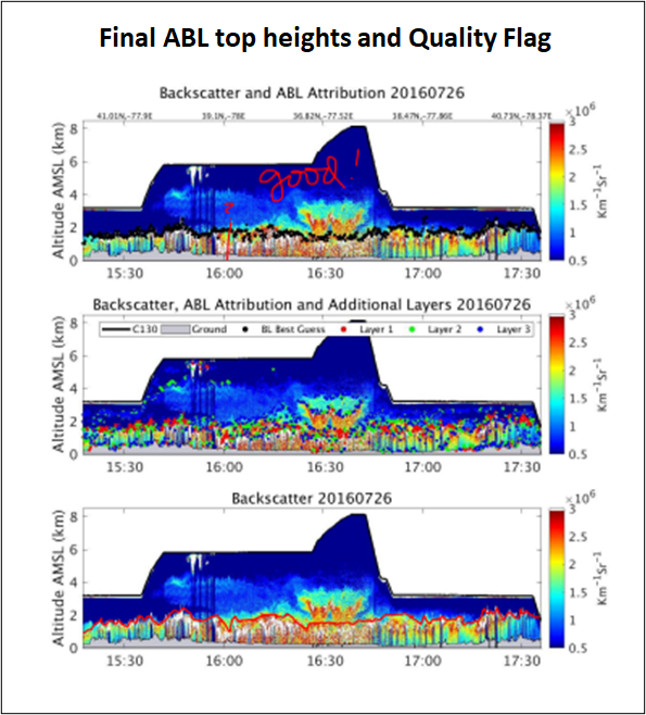
This dataset consists of the atmospheric boundary layer (ABL) top heights and altitudes of two additional aerosol layers derived from Cloud Physics Lidar (CPL) measurements using the Haar wavelet transform method. The CPL instrument was deployed onboard NASA's C-130 aircraft to obtain aerosol backscatter profiles during four ACT-America field campaigns (Summer 2016, Winter 2017, Fall 2017, and Spring 2018). CPL is a backscatter lidar designed to operate simultaneously at three wavelengths. The wavelet method allows for atmospheric layers to be picked out in an automated fashion, with relatively high precision.
Investigators performed an expert visual inspection of the measured time-height cross-section of the 2D field of aerosol backscatter profiles as compared with overlaid algorithm-derived ABL top heights and secondary aerosol layers. Based on observed/derived agreement, quality flag values were assigned to each observation of reported ABL top heights.
The ACT-America mission spanned five years and included field campaigns covering all four seasons over central and eastern regions of the United States. ACT-America's objectives were to study the transport and fluxes of atmospheric CO2 and CH4. Two instrumented aircraft platforms, the NASA Langley Beechcraft B-200 King Air and the NASA Wallops Flight Facility's C-130 Hercules, were used to collect high-quality in situ measurements across a variety of continental surfaces and atmospheric conditions. At times they flew directly under Orbiting Carbon Observatory-2 (OCO-2) overpasses to evaluate the ability of OCO-2 to observe high-resolution atmospheric CO2 variations. The C-130 aircraft was also equipped with active remote sensing instruments for planetary boundary layer height detection and column greenhouse gas measurements.
Additional data from ACT-America and other relevant links can be found on the ORNL DAAC's ACT-America Project Page.
Citation: Pal, S., K.J. Davis, R.M. Pauly, M.J. McGill, L.J. Campbell, K. Hoffman, A.M. Alejandro, M. Rench, and H. Haas. 2021. ACT-America: CPL-derived Atmospheric Boundary Layer Top Height, Eastern US, 2016-2018. ORNL DAAC, Oak Ridge, Tennessee, USA. https://doi.org/10.3334/ORNLDAAC/1825