
The ORNL DAAC recently released this dataset from the Carbon Monitoring Systems (CMS) project by Goldberg, L., et al., (2022):
Global Mangrove Loss Extent, Land Cover Change, and Loss Drivers, 2000-2016
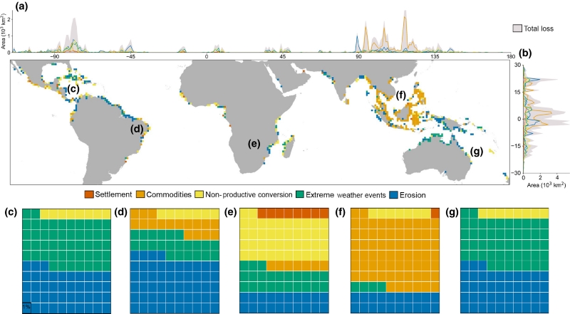
This dataset provides estimates of the extent of mangrove loss, land cover change, and its anthropogenic or climatic drivers in three time periods: 2000-2005, 2005-2010, and 2010-2016. Landsat-based Normalized Difference Vegetation Index (NDVI) anomalies were used to determine loss extent in each period. The drivers of mangrove loss were determined by examining land cover changes using a random forest machine learning technique that considered change from mangrove to wet soil, dry soil, and water at each loss pixel. A series of decision trees used several global-scale land-use datasets to identify the ultimate driver of the mangrove loss. Loss drivers include commodity production (agriculture, aquaculture), settlement, erosion, extreme climatic events, and non-productive conversion. Maps of loss extent per period, mangrove land cover changes, and loss drivers are provided for each of 39 mangrove holding nations.
The NASA CMS program is designed to make significant contributions in characterizing, quantifying, understanding, and predicting the evolution of global carbon sources and sinks through improved monitoring of carbon stocks and fluxes. The System uses NASA satellite observations and modeling/analysis capabilities to establish the accuracy, quantitative uncertainties, and utility of products for supporting national and international policy, regulatory, and management activities. CMS data products are designed to inform near-term policy development and planning.
Additional data from Carbon Monitoring System (CMS) project and other relevant links can be found on the ORNL DAAC's CMS Project Page.
Citation: Goldberg, L., D. Lagomasino, N. Thomas, and T. Fatoyinbo. 2022. Global Mangrove Loss Extent, Land Cover Change, and Loss Drivers, 2000-2016. ORNL DAAC, Oak Ridge, Tennessee, USA. https://doi.org/10.3334/ORNLDAAC/1768