
ABoVE: Hyperspectral Imagery from AVIRIS-NG, Alaskan and Canadian Arctic, 2017-2018
This dataset has been updated to include data collected during 2018 flights over the Arctic-Boreal Vulnerability Experiment (ABoVE) domain. The dataset provides Level 1 radiance and Level 2 surface reflectance measured by the Airborne Visible/Infrared Imaging Spectrometer-Next Generation (AVIRIS-NG) instrument. Spectra measured by AVIRIS-NG are used to identify, measure, and monitor constituents of the Earth's surface and atmosphere. Ecological applications include species composition, structure, and function; chlorophyll, leaf water, lignin, cellulose, pigment, and non-photosynthetic constituent content.
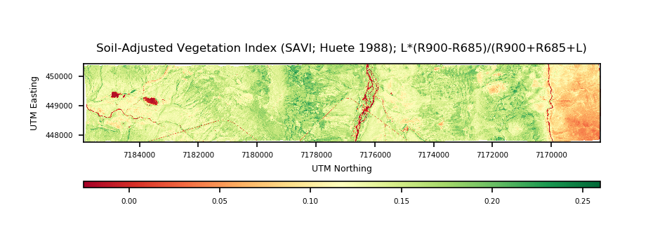
AVIRIS-NG data file sizes can be prohibitively large owing to the large number of raster bands. We created a new tutorial to show users how to work with this data in Python. The tutorial demonstrates how to extract AVIRIS-NG imagery at specific locations, plot individual bands, calculate NDVI and other vegetation indices, and save outputs.
Tutorial: Basic processing of hyperspectral imagery from AVIRIS-NG
We also offer a video tutorial showing how to find and download AVIRIS-NG data from the ABoVE campaign for your region of interest.
Video: AVIRIS-NG Data Search
The Arctic-Boreal Vulnerability Experiment (ABoVE) is a NASA Terrestrial Ecology Program field campaign that links field-based, process-level studies with geospatial data products derived from airborne and satellite sensors.
Data Citation: Miller, C.E., R.O. Green, D.R. Thompson, A.K. Thorpe, M. Eastwood, I.B. Mccubbin, W. Olson-duvall, M. Bernas, C.M. Sarture, S. Nolte, L.M. Rios, M.A. Hernandez, B.D. Bue, and S.R. Lundeen. 2019. ABoVE: Hyperspectral Imagery from AVIRIS-NG, Alaskan and Canadian Arctic, 2017-2018. ORNL DAAC, Oak Ridge, Tennessee, USA. https://doi.org/10.3334/ORNLDAAC/1569

