
The ORNL DAAC recently released a new dataset from the Carbon Monitoring System (CMS) project by Parra, A., et al., (2022):
CMS: Vegetative Lifeform Cover from Landsat SR for CONUS, 1984-2018
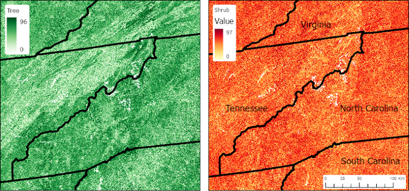
This dataset contains estimates of percent cover of tree, shrub, herb, and other (non-vegetation) lifeform classes and uncertainties for the conterminous U.S. (CONUS). The estimates were derived using quantile regression forest models and indicate the percent of ground covered by a vertical projection of each lifeform class ranging from 0 to 100 percent. Model input data included Landsat surface reflectance (SR) data and 165 airborne LiDAR datasets covering eight of the eleven terrestrial biomes of the conterminous U.S. and Alaska. Eighty-six of the LiDAR acquisitions are part of the NASA Goddard's LiDAR, Hyperspectral, and Thermal Imager (G-LiHT) airborne imager data collection; the remaining 79 sites were acquired by the National Science Foundation's National Ecological Observatory Network Airborne Observation Platform (NEON AOP). Acquisitions were selected based on the availability of the SR data for each G-LiHT and NEON dataset. The data are annual estimates from 1984 to 2018 and were tiled (425 tiles) using the CONUS Landsat Analysis Ready Data (ARD) grid scheme. Data are provided in GeoTIFF format.
The NASA CMS program is designed to make significant contributions in characterizing, quantifying, understanding, and predicting the evolution of global carbon sources and sinks through improved monitoring of carbon stocks and fluxes. The System uses NASA satellite observations and modeling/analysis capabilities to establish the accuracy, quantitative uncertainties, and utility of products for supporting national and international policy, regulatory, and management activities. CMS data products are designed to inform near-term policy development and planning.
Additional data from Carbon Monitoring System (CMS) project and other relevant links can be found on the ORNL DAAC's CMS Project Page.
Citation: Parra, A., and J.A. Greenberg. 2021. CMS: Vegetative Lifeform Cover from Landsat SR for CONUS, 1984-2018. ORNL DAAC, Oak Ridge, Tennessee, USA. https://doi.org/10.3334/ORNLDAAC/1809