
Mangrove forests are found in coastal areas at tropical and subtropical latitudes. They are biologically complex ecosystems that provide sanctuaries for wildlife and protect shorelines from erosion. They are also considered to be one of the most productive and carbon dense ecosystems on earth. These unique attributes have made them the focus of researchers who are looking to estimate the amount of carbon stored in mangrove forests around the world and the effects of mangrove deforestation on the global carbon budget. See the Blue Carbon Initiative for more information.
The ORNL DAAC has recently published three new data sets from NASA's Carbon Monitoring System with information on mangrove forests in Mozambique and Tanzania. These estimates of mangrove canopy height, stand age, and land cover change can be used to estimate the role of these ecosystems in the global carbon budget.
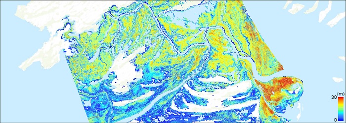
CMS: Mangrove Canopy Height from High-resolution Stereo Image Pairs, Mozambique, 2012
This data set provides canopy height, land cover change, and stand age estimates for mangrove forests in the Rufiji River Delta in Tanzania. The estimates were derived from a canopy height model (CHM) using TanDEM-X imagery and Polarimetric SAR interferometry (Pol-InSAR) techniques. Landsat imagery circa 1990 and circa 2014 was used to estimate stand age between 1994 and 2014 and for forest land cover change modeling.
CMS: Mangrove Canopy Height Estimates from Remote Imagery, Zambezi Delta, Mozambique
This data set provides high resolution canopy height estimates for mangrove forests in the Zambezi Delta, Mozambique, Africa. The estimates were derived from three separate canopy height models (CHM) using airborne Lidar data, stereophotogrammetry with WorldView 1 imagery, and Interferometric-Synthetic Aperture Radar (In-SAR) techniques with TanDEM-X imagery. The data cover the period 2011-10-14 to 2014-05-06.
CMS: Mangrove Canopy Characteristics and Land Cover Change, Tanzania, 1990-2014
This data set provides canopy height estimates for mangrove forests at 0.6 x 0.6 m resolution in three study sites located in southeastern Mozambique, Africa: two sites on Inhaca Island and one in the Maputo Elephant Reserve, located in the southern province of Maputo for September, 2012. The estimates were derived from WorldView1 (WV-1) very high resolution (VHR) stereo images processed using the Ames Stereo Pipeline (ASP) digital surface model (DSM) tool.
For more on the investigator's research on mangrove forests, see MangroveScience.org
Related Reading:
Lagomasino, D., Fatoyinbo, T. Lee, S., and Simard, M. 2015. High-resolution forest canopy height estimation in an African blue carbon ecosystem. Remote Sens. Ecol. Conserv. 1, 51–60. http://dx.doi.org/10.1002/rse2.3
Lagomasino, D., Fatoyinbo, T., Lee, S., Feliciano, L., Trettin, C., and Simard, M. A. 2016. Comparison of Mangrove Canopy Height Using Multiple Independent Measurements from Land, Air, and Space. Remote Sens. 8(4), 327; http://dx.doi.org/10.3390/rs8040327
