
A new dataset presents a robust approach for using airborne LiDAR data and high-resolution airborne imagery to accurately map low-stature shrub biomass in Arctic tundra. The high-resolution shrub biomass maps produced in this study are a valuable baseline reference that will be useful to researchers seeking to understand tundra vegetation dynamics, or to improve estimates of carbon flux, nutrient cycling, and wildlife habitat in the rapidly changing tundra biome (Greaves et al., 2016).
High-Resolution Shrub Biomass and Uncertainty Maps, Toolik Lake Area, Alaska, 2013
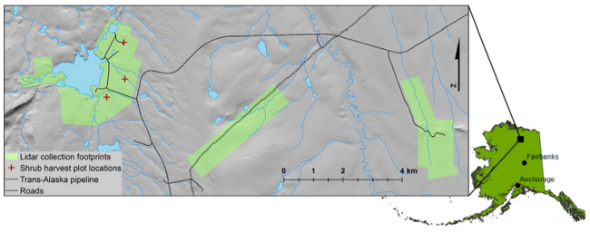
This dataset contains estimates for aboveground shrub biomass and uncertainty at high spatial resolution (0.80-m) across three research areas near Toolik Lake, Alaska. The estimates for August of 2013 were generated and mapped using Random Forest modeling with input variables of optimized LiDAR-derived canopy volume and height, mean NDVI from 4-band RGB color and near-IR orthophotographs, and harvested biomass data. Uncertainty in the final shrub biomass maps was quantified by producing separate maps showing the coefficient of variation (CV) of the Random Forest map estimates. Shrub biomass was harvested at Toolik Lake in 2014 and used to optimize inputs and validate the final model and these biomass data are also provided.
Related Publication:
Greaves, H.E., Vierling, L. A., Eitel, J.U.H, Boelman, N.T., Magney, T.S., Prager, C.M., & Griffin, K.L. (2016). High-resolution Mapping of Aboveground Shrub Biomass in Arctic Tundra Using Airborne Lidar and Imagery. Remote sensing of environment,(184), 361-373. http://dx.doi.org/10.1016/j.rse.2016.07.026
Data Citation:
Greaves, H.E., L. Vierling, J. Eitel, N. Boelman, T. Magney, C. Prager, and K. Griffin. 2018. High-Resolution Shrub Biomass and Uncertainty Maps, Toolik Lake Area, Alaska, 2013. ORNL DAAC, Oak Ridge, Tennessee, USA. https://doi.org/10.3334/ORNLDAAC/1573
Data center: ORNL DAAC
Sponsor: NASA EOSDIS
