
The ORNL DAAC recently released a new dataset from the Carbon Monitoring System (CMS) project by Park, T., et al., (2022):
Tree Cover Estimates at 30 m Resolution for Mexico, 2016-2018
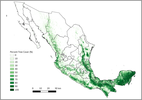
The data set provides multi-year (2016-2018) percent tree cover (TC) estimates for entire Mexico at 30 m spatial resolution. The TC data (hereafter, NEX-TC) was derived from the 30 m Landsat Collection 1 product and a hierarchical deep learning approach (U-Net) developed in a previous CMS effort for the conterminous United States (CONUS) (Park et al., 2022). The hierarchical U-Net framework first developed a U-Net model for very high-resolution aerial images (NAIP) using training labels derived from previous work based on an interactive image segmentation tool and iterative updates with expert knowledge (Basu et al., 2015). The developed NAIP U-Net model and NAIP data produced 1-m NAIP TC across all lower 48 CONUS states. A Landsat U-Net model was developed for multi-year and large-scale TC mapping based on the very high-resolution NAIP TC made in the earlier stage. The Landsat U-Net model developed was adopted over the CONUS for testing its transferability, validation, and improvement across Mexico. This dataset provides national-scale percent tree cover estimates over Mexico and can be helpful for studies of carbon cycling, land cover and land use change, etc. The team has been working on improving temporal stability of the product and will update the product once the next version is ready to be shared.
The NASA CMS program is designed to make significant contributions in characterizing, quantifying, understanding, and predicting the evolution of global carbon sources and sinks through improved monitoring of carbon stocks and fluxes. The System uses NASA satellite observations and modeling/analysis capabilities to establish the accuracy, quantitative uncertainties, and utility of products for supporting national and international policy, regulatory, and management activities. CMS data products are designed to inform near-term policy development and planning.
Additional data from Carbon Monitoring System (CMS) project and other relevant links can be found on the ORNL DAAC's CMS Project Page.
Citation: Park, T., and R. Vargas. 2022. Tree Cover Estimates at 30 m Resolution for Mexico, 2016-2018. ORNL DAAC, Oak Ridge, Tennessee, USA. https://doi.org/10.3334/ORNLDAAC/2137