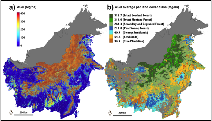
Aboveground Biomass, Landcover, and Degradation, Kalimantan Forests, Indonesia, 2014
This new dataset provides estimates of aboveground biomass, percent canopy cover, mean canopy height, landcover, and forest degradation index products for forests in Kalimantan, Indonesia (Island of Borneo), representative of conditions in late 2014. Data were combined from several sources, including field sampling, airborne lidar, satellite measurements, a forest-type land cover map, and integrated into a random forest algorithm to produce these estimates. The goal of the study was to develop a wall-to-wall map of aboveground biomass (AGB) density for the forests in the Kalimantan region of Indonesia.
The NASA Carbon Monitoring System (CMS) uses the full range of NASA satellite observations and modeling/analysis capabilities to establish the accuracy, quantitative uncertainties, and utility of products for supporting national and international policy, regulatory, and management activities that are related to carbon stocks and fluxes. See all ORNL DAAC datasets from the Carbon Monitoring System.
Related Paper: Ferraz, et al. 2018. Carbon Storage Potential in Degraded Forests of Kalimantan, Indonesia. Environ. Res. Lett. 13, 095001. https://doi.org/10.1088/1748-9326/aad782
Data Citation: Ferraz, A., S.S. Saatchi, L. Xu, S. Hagen, J. Chave, Y. Yu, V. Meyer, M. Garcia, C. Silva, O. Roswintiarti, A. Samboko, P. Sist, S.M. Walker, T. Pearson, A. Wijaya, F.B. Sullivan, E. Rutishauser, D. Hoekman, and S. Ganguly. 2019. Aboveground Biomass, Landcover, and Degradation, Kalimantan Forests, Indonesia, 2014. ORNL DAAC, Oak Ridge, Tennessee, USA. https://doi.org/10.3334/ORNLDAAC/1645
Data Center: ORNL DAAC
Sponsor: EOSDIS


