Body
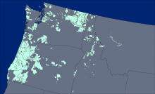
The North American Forest Dynamics Attribution product provides information depicting forest change across 258 million ha of the conterminous U.S.

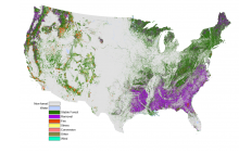
North American Forest Dynamics (NAFD) attribution type layer illustrating the type of change event where all events from 1986-2010 were combined. Source: Schleeweis et al. (2020) https://doi.org/10.3334/ORNLDAAC/1799
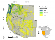
Forested land in the western conterminous United States classified by priority for preservation to mitigate climate change, based on the spatial co-occurrence of vulnerability to drought and fire and potential carbon sequestration. Source: Buotte et al. 2020
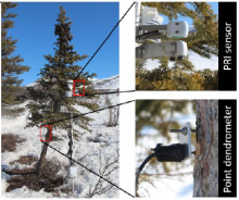
A white spruce tree is instrumented with a hemispherical and field-stop photochemical reflectance index (PRI) sensor and point dendrometer at a northern treeline site along the Dalton Highway, Brooks Range, Alaska. Source: Eitel et al., 2020
The tree density per hectare is shown for different crown size classes: (a) 3-15 m2, (b) 15-50 m2, (c) 50-200 m2, (d) >200 m2. Source: Brandt et al. (2020)
The locations of the 176 lidar collection areas (light green polygons) acquired between 2002 and 2016.
Aboveground biomass was derived from forest inventory data and lidar imagery.
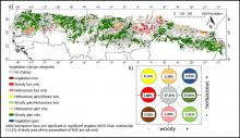
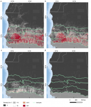
Concurrent woody and herbaceous vegetation changes between the 1982-1991 and 2004-2013 decades of the Sudano-Sahel region of Africa. (A) Map of vegetation change categories. (B) Chart showing the conceptual position and the relative abundance of each category in a 2-D space.
Vegetation change data spanning the West African Sudano-Sahel region is now available.
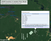
Bounding boxes for LiDAR tiles from surveys over western Para, Brazil, are depicted in Google Earth from the KMZ companion file. Each feature in the KMZ provides key metadata about the corresponding tile.
LiDAR surveys over forest research sites across the Amazon rainforest in Brazil are available.

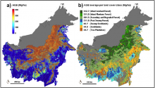
Aboveground biomass (AGB) density maps of Kalimantan forests. (A) AGB density, and (B) mean density AGB aggregated by land cover class. From Ferraz et al., 2018.
A new dataset from the Carbon Monitoring System provides forest biomass, canopy height, and degradation maps across the Indonesian portion of the island of Borneo.

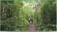
Researchers collecting field data in Mondah Forest, Gabon, for the AfriSAR project. Photo credit: Carla Thomas, NASA, 2016
Tree data, canopy cover, and vertical profile metrics from forests in Gabon have been published.
