Body
Locations and number of methane ebullition hotspots in frozen lakes in the southern portion of the Goldstream Valley and surroundings near Fairbanks, Alaska.

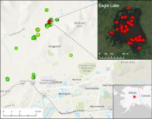
Location of 15 lakes surveyed for methane ebullition hotspots (green points) north of Fairbanks, AK, on October 8, 2014. Inset shows detail of Eagle Lake with locations of 43 hotspots (red points) detected by openings in lake ice.
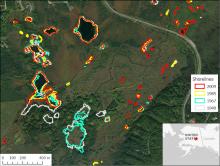
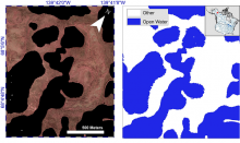
Shorelines of lakes northwest of Fairbanks, AK, over a 60 year period mapped from aerial photographs and satellite imagery. Notice the shoreline shift.
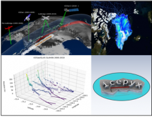
Laser Altimetry Datasets from NASA's ICESAT, IceBridge, and ICESat-2 missions are harmonized with Python tools to understand the evolution of land and sea ice.
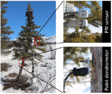
A white spruce tree is instrumented with a hemispherical and field-stop photochemical reflectance index (PRI) sensor and point dendrometer at a northern treeline site along the Dalton Highway, Brooks Range, Alaska. Source: Eitel et al., 2020
Example of Color-infrared imagery shown alongside the corresponding semi-automated open water classification at Old Crow Flats, Alaska.
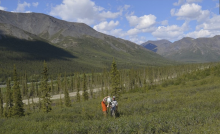
A perspective of one study plot at the forest-tundra ecotone with mature spruce trees transitioning into short-stature trees and low-stature deciduous shrubs.
Terrestrial lidar scanning point cloud data are available for research plots in the Brooks Range of Alaska.
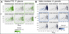
Relationship between the quantum yields of fluorescence (Ft) and photosystem II (Fv/Fm) sampled Picea glauca needles in Alaska (A) and Abies grandis needles in Idaho (B). Modeled (A) and observed (B) irradiance is indicated by the coloration of points; grey points in individual sampling period panels show observations from all periods for reference. Plots of sampling periods aligned with the timing of satellite overpasses are outlined in green (A) and blue (B) boxes, respectively.
In situ measurements of needle-level chlorophyll fluorescence and other irradiance products are now available.
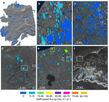
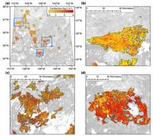
SAR-based lake ebullition maps. Panel a shows Alaska study regions with SAR footprints outlined in yellow. Subsequent panels show SAR-based CH4 ebullition maps for b) Barrow Peninsula, c) Atqasuk, d) Toolik, e) northern Seward Peninsula, and f) Fairbanks. Study lakes with field-based measurements are outlined (b,c) or boxed (d,e,f) in white. Orange boxes in panel f indicate anthropogenic study lakes.
Synthetic Aperture Radar (SAR) was used to estimate methane ebullition flux for thousands of lakes in five regions across Alaska.
Spatial estimates of total carbon combustion at 30 m resolution across the 2015 fire perimeters in Saskatchewan (a) and sampled fires (b, c, d). The spatial extents of sampled fires are shown as blue rectangles in (a).
A new Arctic-Boreal Vulnerability Experiment (ABoVE) provides spatial estimates of carbon combustion and uncertainty on a 30 m grid.
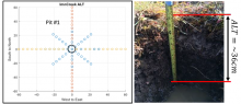
Site sampling plan used for characterizing active layer soils (left). Axes are in meters. At Imnavait Creek, active layer thickness (ALT) was measured on transects intersecting a central soil pit. Soil dielectric properties, in situ moisture and temperature profiles were measured, and soil samples were collected for analyses from the soil pit (right).
Active layer thickness, soil dielectric profiles, and soil physical properties are key variables for understanding the Arctic permafrost layer.