
ABoVE: AirSWOT Water Masks from Color-Infrared Imagery over Alaska and Canada, 2017
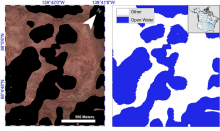
This dataset from the Arctic-Boreal Vulnerability Experiment (ABoVE) provides a conservative open water mask for future water surface elevation extraction from the co-registered AirSWOT Ka-band interferometry data, and high-resolution (1 m) water body distribution maps for water bodies greater than 40 m2 along foundational flight lines. The masks and maps were derived from georeferenced three-band orthomosaics generated from individual images collected during the flights and semi-automated water classification algorithm based on the Normalized Difference Water index. The image tiles were georeferenced using manually selected ground control points. Automated detection of surface waters supports the interpretation of coincident ABoVE image products and offers potential for multi-sensor analysis.
ABoVE is a NASA Terrestrial Ecology Program field campaign being conducted in Alaska and western Canada for 8 to 10 years, starting in 2015. Research for ABoVE links field-based, process-level studies with geospatial data products derived from airborne and satellite sensors, providing a foundation for improving the analysis, and modeling capabilities needed to understand and predict ecosystem responses to, and societal implications of, climate change in the Arctic and Boreal regions.
Data Citation: Kyzivat, E.D., L.C. Smith, L.H. Pitcher, J.V. Fayne, S.W. Cooley, M.G. Cooper, S. Topp, T. Langorst, M.E. Harlan, C.J. Gleason, and T.M. Pavelsky. 2019. ABoVE: AirSWOT Water Masks from Color-Infrared Imagery over Alaska and Canada, 2017. ORNL DAAC, Oak Ridge, Tennessee, USA. https://doi.org/10.3334/ORNLDAAC/1707 .