Body
Hourly in-situ soil moisture measurements from data loggers in predominantly organic soils along the Sag River and near Red Earth Creek.

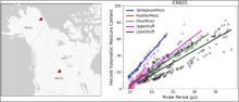
Location of sites in Alaska, U.S., and Alberta, Canada (left, red triangles) and calibration plot (right) for the Campbell Scientific CS625 soil moisture sensor and five types of organic soils.
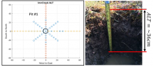
Site sampling plan used for characterizing active layer soils (left). Axes are in meters. At Imnavait Creek, active layer thickness (ALT) was measured on transects intersecting a central soil pit. Soil dielectric properties, in situ moisture and temperature profiles were measured, and soil samples were collected for analyses from the soil pit (right).
Active layer thickness, soil dielectric profiles, and soil physical properties are key variables for understanding the Arctic permafrost layer.
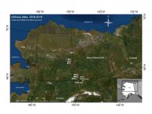
Sixteen measurement sites located across interior Alaska, USA, and at one site in Yukon, Canada. Sites C17K, C26K, E23, F17, H31, and I17 are collocated with the seismic stations.
New soil temperature profile measurements collected at USArray stations are available from the Arctic-Boreal Vulnerability Experiment (ABoVE).
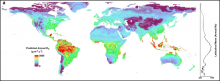
A global map of predicted annual soil respiration (Rs) at 1 km spatial resolution created by applying the QRF model to gridded covariates. Right is a plot of the latitudinal mean predicted annual Rs.
A machine learning approach was used to derive the predicted annual soil respiration and uncertainty at a 1 km spatial resolution.

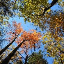
Upward-facing photo of the canopy at Harvard Forest (transect 2, plot 57) on 2012-10-18.
Ground-based data collected at the Harvard Forest site was used to validate Airborne Microwave Observatory of Subcanopy and Subsurface (AirMOSS) soil moisture estimates.

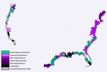
Estuaries classes used in the study: former river valley primary estuary, former glacier valley primary estuary, river delta primary estuary, tectonic structural primary estuary, coastal lagoon secondary estuary, and unclassified estuary.
Soil organic carbon (SOC) estimates and environmental data for US estuaries are available for the period 1972-2015.

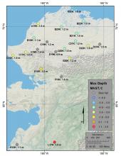
USArray measurement sites in Alaska. Sites are labeled with site ID and maximum measurement depth and color-coded by mean annual ground temperature (MAGT in degrees C) of the deepest sensor measurements. Data are omitted for sites disrupted by bears.
Soil temperature data were collected at Alaskan USArray seismic monitoring sites from 2016-2018.

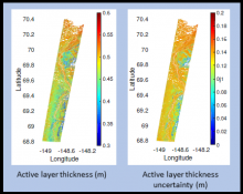
Active layer thickness with uncertainty for a flight swath over the northern section of Alaska's Dalton Highway in summer 2015.
NASA's ABoVE airborne campaign provides estimates of active layer thickness and soil properties derived from the AirMOSS instrument.

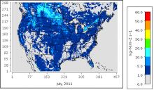
Soil nitrous oxide emissions on a monthly average basis for July 2011 estimated with the mechanistic scheme.
A new model dataset improves the timing and spatial distribution of estimates of soil nitrogen emissions.

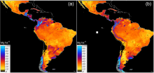
Country-specific (a) and regional (b) predictions of SOC across Latin America based on a linear ensemble of methods.
A new dataset offers baseline estimates of soil organic carbon for Latin American countries.
