Body
Synthetic Aperture Radar (SAR) was used to estimate methane ebullition flux for thousands of lakes in five regions across Alaska.

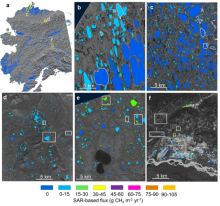
SAR-based lake ebullition maps. Panel a shows Alaska study regions with SAR footprints outlined in yellow. Subsequent panels show SAR-based CH4 ebullition maps for b) Barrow Peninsula, c) Atqasuk, d) Toolik, e) northern Seward Peninsula, and f) Fairbanks. Study lakes with field-based measurements are outlined (b,c) or boxed (d,e,f) in white. Orange boxes in panel f indicate anthropogenic study lakes.
Synthetic Aperture Radar (SAR) was used to estimate methane ebullition flux for thousands of lakes in five regions across Alaska.
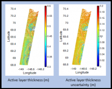
Active layer thickness with uncertainty for a flight swath over the northern section of Alaska's Dalton Highway in summer 2015.
NASA's ABoVE airborne campaign provides estimates of active layer thickness and soil properties derived from the AirMOSS instrument.

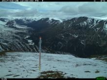
A remote camera image showing the snow stake at Plot 15 of the Jaeger Mesa/Rambler Mine study area.
Automated digital cameras provide a record of snow conditions in Alaska's Dall sheep habitat.
