Body
Breakthrough Forest Biomass-Carbon Product, GEDI L4B Gridded AGBD now available from critical advancements in spaceborne lidar research.

NASA's GEDI observable is the lidar waveform, all products are derived from it.
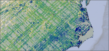
This screen capture from the GEDI L4B mean aboveground biomass density layer shows the crisscross pattern of GEDI's laser tracks on the Earth's terrestrial surface.
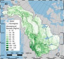
Spatial distribution of predicted aboveground biomass (AGB) density averaged over 1984-2014 for the ABoVE Core Study Domain. Ecoregions represent the EPA Level 2 Ecoregion boundaries. Source: Wang et al. (2021)
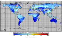
Gross primary production from FluxSat v2.0 expressed as carbon (g m-2 d-1) for July 1st, 2019.
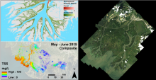
Pre-DeltaX image highlights: AVIRIS-NG/UAVSAR Biomass (upper left), AVIRIS-NG Total Suspended Solids (lower left), and AVIRIS-NG Surface Reflectance (right).
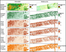
Gridded Land, Vegetation, and Ice Sensor (LVIS) instrument data products at 25 m spatial resolution over the Mondah Forest (left) and Mabounie (right) sites in Gabon.
NASA's airborne Land, Vegetation, and Ice Sensor (LVIS) instrument was used to collect inventory data for Gabon's forests.
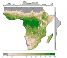
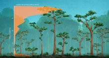
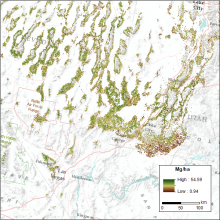
Estimates of woody biomass (tree and shrubs) at 1-km resolution in megagrams per hectare (Mg ha-1). Biomass was estimated from canopy cover, canopy height, and tree allometry. Source: C.W. Ross
Estimates of woody cover and biomass across sub-Saharan Africa were derived from observations, tree allometry equations, and remote-sensing products.
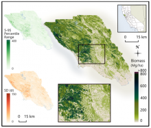
Estimated aboveground biomass (Mg/ha) for Sonoma County at 30 m spatial resolution with the 5th-95th percentile range and the standard deviation (SD) of per-pixel biomass estimates shown in the top left and bottom left, respectively.
A new dataset used a parametric modeling approach to estimate biomass from airborne LiDAR data and field measurements.
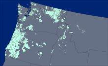
The locations of the 176 lidar collection areas (light green polygons) acquired between 2002 and 2016.
Aboveground biomass was derived from forest inventory data and lidar imagery.
Maps of live tree biomass in pinyon-juniper forests are available for the years 2000-2016.