Body
Annual land use/cover (LUC) maps at 30 m resolution across Mawas, Central Kalimantan, Indonesia.

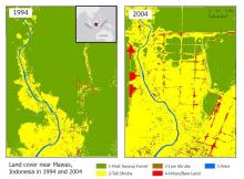
Land cover maps at 30 m resolution across Mawas, Central Kalimantan, Indonesia in 1994 (left) and 2004 (right).
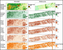
Gridded Land, Vegetation, and Ice Sensor (LVIS) instrument data products at 25 m spatial resolution over the Mondah Forest (left) and Mabounie (right) sites in Gabon.
NASA's airborne Land, Vegetation, and Ice Sensor (LVIS) instrument was used to collect inventory data for Gabon's forests.
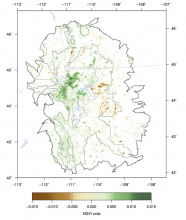
Trends in maximum annual NDVI for natural vegetation within the Greater Yellowstone Ecosystem (GYE) from 1989 to 2014 (Emmett et al. 2019).
Daymet and North American Carbon Program (NACP) data were used to study Normalized Difference Vegetation Index (NDVI) trends across the Greater Yellowstone Ecosystem.

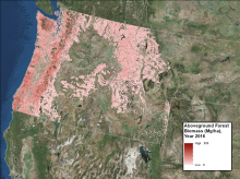
Forest aboveground biomass in megagrams per hectare for the year 2016.
Annual maps of aboveground biomass are available for forests in Washington, Oregon, Idaho, and western Montana, USA.

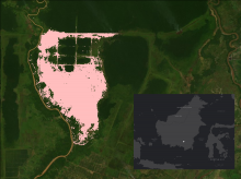
The area burned in 1997 and 1998 in the Mawas area, Central Kalimantan, Indonesia is shown in pink. The inset with white dot shows the location of Mawas study site on the Island of Borneo.
Maps of annual burned area from 1997 to 2015 show the extent of fires in the Mawas region of Central Kalimantan.
