Body
NASA's airborne Land, Vegetation, and Ice Sensor (LVIS) instrument was used to collect inventory data for Gabon's forests.

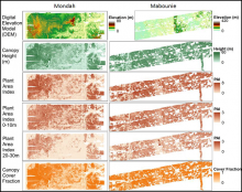
Gridded Land, Vegetation, and Ice Sensor (LVIS) instrument data products at 25 m spatial resolution over the Mondah Forest (left) and Mabounie (right) sites in Gabon.
NASA's airborne Land, Vegetation, and Ice Sensor (LVIS) instrument was used to collect inventory data for Gabon's forests.
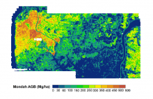
Aboveground biomass mapped at 0.25 ha resolution for the Mondah study site in Gabon, West Africa.
The AfriSAR campaign produced maps of aboveground biomass for four forested sites in Gabon based on field data and LiDAR scans.

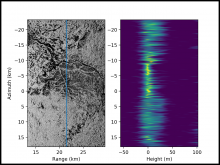
Tomographic image of Lope National Park for the cross-section marked by the blue line. Note the contrast between dark areas dominated by surface scattering and the bright areas with scattering through the forest canopy.
Three-dimensional maps of forest structure in Gabon are now available from the 2016 AfriSAR campaign.

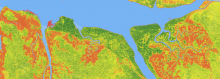
This image shows the height of the forest canopy for a portion of the Pongara National Park along the Gabon Estuary in Gabon, West Africa. This area includes some of the tallest mangrove forests in the world, indicated by a dark green color, where trees tower up to 60 meters (200 feet). The data were estimated by fusion of PolInSAR and LiDAR data collected by the AfriSAR campaign in March 2016.
NASA’s AfriSAR campaign measured forest structure in Gabon, West Africa to inform estimates of forest carbon storage capacity.

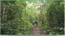
Researchers collecting field data in Mondah Forest, Gabon, for the AfriSAR project. Photo credit: Carla Thomas, NASA, 2016
Tree data, canopy cover, and vertical profile metrics from forests in Gabon have been published.
