
AfriSAR: Aboveground Biomass for Lope, Mabounie, Mondah, and Rabi Sites, Gabon
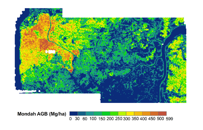
This new dataset from the AfriSAR mission provides gridded estimates of aboveground biomass (AGB) for four sites in Gabon at 0.25 ha (50 m) resolution derived with field measurements and airborne LiDAR data collected from 2010 to 2016. Plot-level biophysical measurements of tree diameter and tree height were performed at multiple plots within each site. Aerial LiDAR scans were used to construct digital elevation models and digital surface models, and then these were used to construct a canopy height model (CHM). Mean canopy height (MCH) was computed, then a single regression model was constructed to relate MCH and AGB estimates and incorporating local canopy height. Model output was combined with CHM to construct one biomass map for each of the for sites.
AfriSAR was an airborne campaign that collected radar and field measurements of tropical forests in Gabon, West Africa, in collaboration with the European Space Agency and the Gabonese Space Agency. The data collected is a precursor to upcoming spaceborne missions that examine the role of forests in Earth's carbon cycle. See all data from AfriSAR.
Data Citation: Saatchi, S.S., J. Chave, N. Labriere, N. Barbier, M. Maxime-Rejou, A. Ferraz, and S. Tao. 2019. AfriSAR: Aboveground Biomass for Lope, Mabounie, Mondah, and Rabi Sites, Gabon. ORNL DAAC, Oak Ridge, Tennessee, USA. https://doi.org/10.3334/ORNLDAAC/1681
Data Center: ORNL DAAC
Sponsor: EOSDIS
