
Data from the North American Carbon Program (NACP) and Daymet, both archived at the ORNL DAAC, were used for a recent analysis of Normalized Difference Vegetation Index (NDVI) trends in the Greater Yellowstone Ecosystem (GYE). NDVI indicates the density of vegetation (i.e., the "greenness" of a given area) and is used as an indicator for plant photosynthetic activity. Increases in atmospheric carbon dioxide are expected to increase plant growth, resulting in greening trends that can be quantified using NDVI.
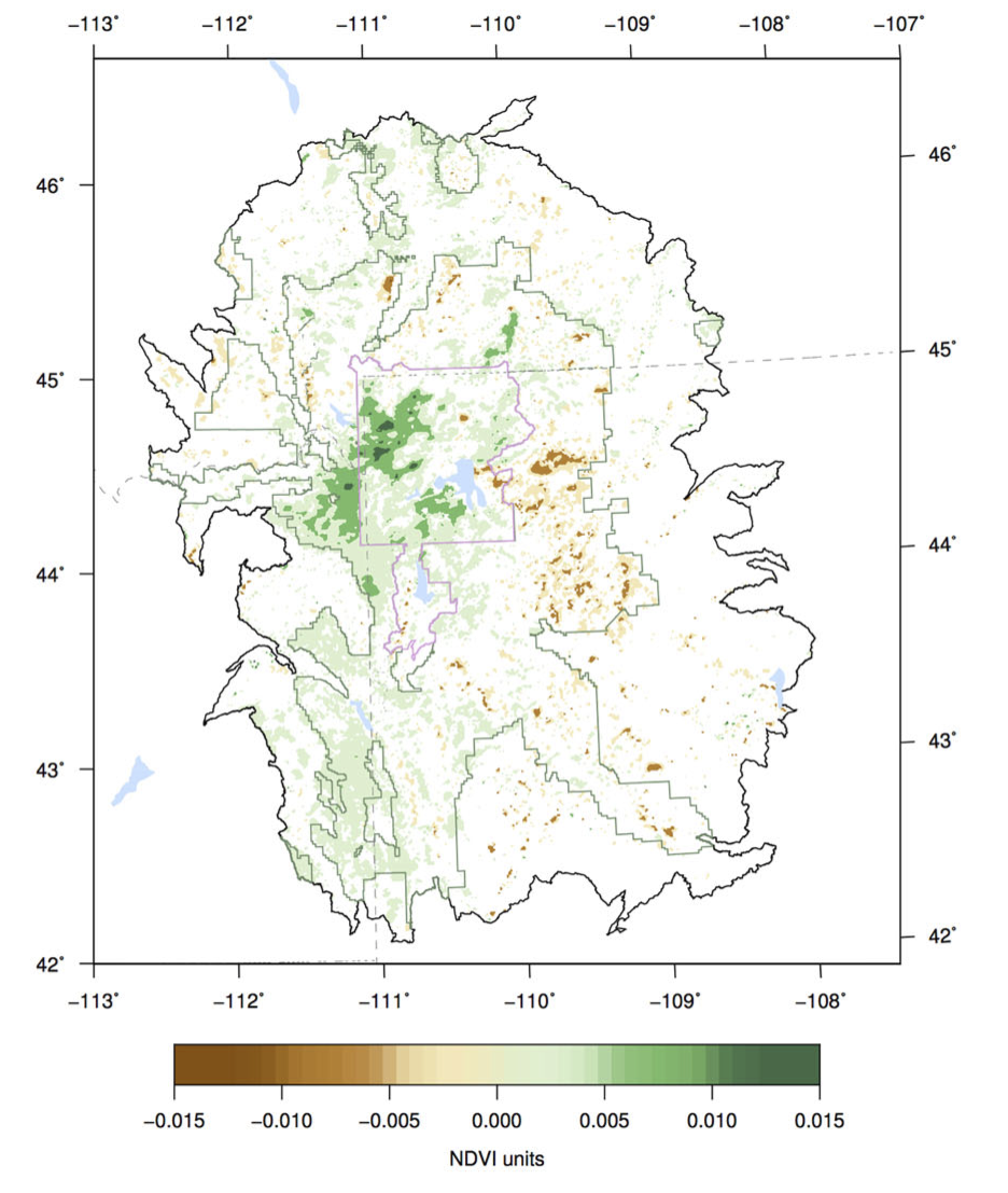
Emmett et al (2019) analyzed 25 years (1989–2014) of vegetation greening and browning within the GYE and the relative importance of climate versus disturbance primarily from fires in explaining trends in NDVI. To derive the history of forest disturbance, the authors used the North American Forest Dynamics time-integrated forest disturbance maps, and to account for effects of climate, the authors derived bioclimatic seasonal indices from Daymet Version 3.0 temperature, precipitation, shortwave radiation, vapor pressure, and snow water equivalent parameters. The study found that forest disturbance was detectable in trends of NDVI, and that summer precipitation and annual temperature had a strong influence on NDVI trends. The authors conclude that "further research is needed on the interactive effects of temperature, precipitation, and disturbance on forest productivity and how these relationships may change under future climate conditions."
Publication: Emmett, K.D., Renwick, K.M. & Poulter, B. Disentangling Climate and Disturbance Effects on Regional Vegetation Greening Trends. Ecosystems 22, 873–891 (2019). https://doi.org/10.1007/s10021-018-0309-2
Data Citation: Thornton, P.E., M.M. Thornton, B.W. Mayer, Y. Wei, R. Devarakonda, R.S. Vose, and R.B. Cook. 2016. Daymet: Daily Surface Weather Data on a 1-km Grid for North America, Version 3. ORNL DAAC, Oak Ridge, Tennessee, USA. https://doi.org/10.3334/ORNLDAAC/1328
Daymet is a collection of gridded estimates of daily weather parameters generated by interpolation and extrapolation from daily meteorological observations. Weather parameters in Daymet include daily surfaces of minimum and maximum temperature, precipitation, vapor pressure, radiation, snow water equivalent, and day length produced on a 1 km x 1 km gridded surface over North America, Puerto Rico, and Hawaii. See all Daymet data.
Data Citation: Goward, S.N., C. Huang, F. Zhao, K. Schleeweis, K. Rishmawi, M. Lindsey, J.L. Dungan, and A. Michaelis. 2015. NACP NAFD Project: Forest Disturbance History from Landsat, 1986-2010. ORNL DAAC, Oak Ridge, Tennessee, USA. https://doi.org/10.3334/ORNLDAAC/1290
The North American Carbon Program (NACP) is a multidisciplinary research program designed to improve understanding of North America's carbon sources, sinks, and stocks. The central objective is to measure and understand the sources and sinks of Carbon Dioxide (CO2), Methane (CH4), and Carbon Monoxide (CO) in North America and adjacent oceans. The NACP is supported by a number of different federal agencies. See all ORNL DAAC data from the NACP.

