Body
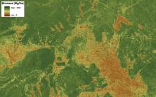
Annual land use/cover (LUC) maps at 30 m resolution across Mawas, Central Kalimantan, Indonesia.

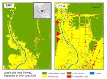
Land cover maps at 30 m resolution across Mawas, Central Kalimantan, Indonesia in 1994 (left) and 2004 (right).

MODIS satellite data inform study of human land use patterns and changes in ecological communities in tropical forests around the world.