
CMS: LiDAR Biomass Improved for High Biomass Forests, Sonoma County, CA, USA, 2013
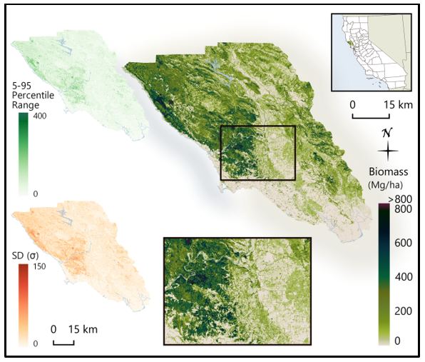
This dataset from the Carbon Monitoring System (CMS) program provides estimates of above-ground woody biomass and uncertainty at a 30 m spatial resolution for Sonoma County, California, USA, for the nominal year 2013. Biomass estimates (Mg/ha) were generated using a combination of airborne LiDAR data and field plot measurements. Using a parametric modeling approach, biomass was predicted as a function of canopy cover and the 50th and 90th percentile LiDAR heights. To estimate the uncertainty of estimates, the biomass model was re-fit 1,000 times through a sampling of the variance-covariance matrix of the fitted model. The 5th and 95th percentiles, and the standard deviation of the biomass estimates are also included.
This new dataset used the same LiDAR data as the related dataset CMS: LiDAR-derived Biomass, Canopy Height and Cover, Sonoma County, California, 2013, but used 30 additional plots sampled in high biomass redwood forests across the county and a parametric modeling approach to estimate biomass.
CMS is designed to make significant contributions in characterizing, quantifying, understanding, and predicting the evolution of global carbon sources and sinks through improved monitoring of carbon stocks and fluxes. The System will use the full range of NASA satellite observations and modeling/analysis capabilities to establish the accuracy, quantitative uncertainties, and utility of products for supporting national and international policy, regulatory, and management activities. CMS will maintain a global emphasis while providing finer scale regional information, utilizing space-based and surface-based data and will rapidly initiate generation and distribution of products both for user evaluation and to inform near-term policy development and planning. See all ORNL DAAC data from the CMS.
Data Citation: Duncanson, L., R.O. Dubayah, J. Armston, M. Liang, A. Arthur, and D. Minor. 2020. CMS: LiDAR Biomass Improved for High Biomass Forests, Sonoma County, CA, USA, 2013. ORNL DAAC, Oak Ridge, Tennessee, USA. https://doi.org/10.3334/ORNLDAAC/1764