DAAC Home > Resources > News

News

rivers

Sea Water Elevation Profile and Change from Pre-Delta-X Campaign Datasets

Submitted by ORNL DAAC Staff on
Image Media
Image Media
Caption

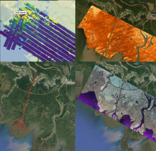
Collage of dataset airborne imagery from AirSWOT, UAVSAR and the ASO lidar instrument provide examination of water level elevation estimates and changes.

Body
Five Pre-Delta-X Airborne datasets recently published provide sea water level profile and change derived from UAVSAR, AirSWOT, and lidar.

Pre-Delta-X: AVIRIS-NG/UAVSAR AGB, AVIRIS-NG TSS and Surface Reflectance

Submitted by ORNL DAAC Staff on
Image Media
Image Media
Caption

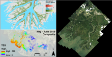
Pre-DeltaX image highlights: AVIRIS-NG/UAVSAR Biomass (upper left), AVIRIS-NG Total Suspended Solids (lower left), and AVIRIS-NG Surface Reflectance (right).

Body
Pre-Delta-X Campaign datasets now available: AGB from AVIRIS-NG/UAVSAR, surface reflectance and total suspended solids from AVIRIS-NG.

The First Campaign of NASA's Delta-X Mission is Now in Progress

Submitted by ORNL DAAC Staff on
Image Media
Image Media
Caption

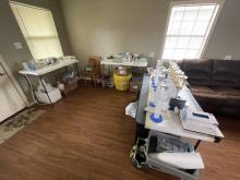
The Channel Team's water filtering lab inside a local cabin. The team will process 800 liters of water to extract as little as ~100mg of material found in a liter of Mississippi water.

Body
NASA's Delta-X Mission combines airborne remote sensing and field measurements to analyze water levels, vegetation, and sediment to understand how and where the Mississippi River Delta is changing.

Annual Estimates of Global Riverine Nitrous Oxide Emissions

Submitted by ORNL DAAC Staff on
Image Media
Image Media
Caption

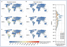
Riverine N2O emission estimates from headwater streams (a, c, and e) and high-order rivers (b, d, and f) for the 1900s, 1960s, and 2000s. The right panel shows the latitudinal distribution of riverine N2O emissions with the uncertainty range as the standard deviation (shaded areas).

Body
Modeled estimates of annual NO2 emissions for two sets of global rivers and streams covering years 1900-2016 available.