
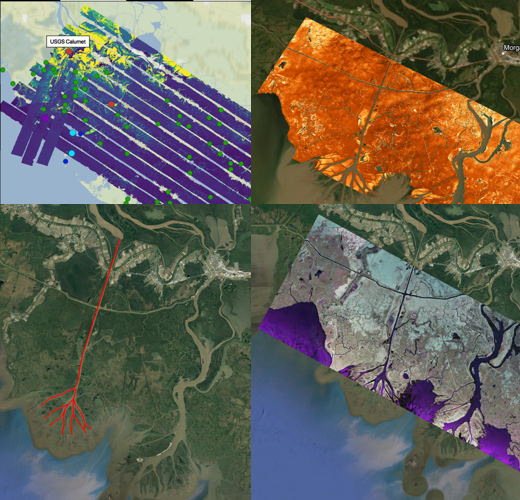
The ORNL DAAC recently published the following five Pre-Delta-X Demonstration datasets:
Pre-Delta-X: L1 UAVSAR Single Look Complex and Interferograms, MRD, LA, USA, 2016
Pre-Delta-X: L2 AirSWOT Water Surface Elevations, Atchafalaya Basin, LA, USA, 2016
Pre-Delta-X: L3 AirSWOT-derived Water Level Profiles, Wax Lake Outlet, LA, USA, 2015
Pre-Delta-X: Lidar-derived Water Level Profiles in the Wax Lake Outlet, LA, USA, 2016
Pre-Delta-X: UAVSAR-derived Water Level Change Maps, Atchafalaya Basin, LA, USA, 2016
These Pre-Delta-X Demonstration Campaign datasets provide comprehensive information on sea elevation profiles and change in the Delta-X study area of the Mississippi River Delta. Data include single look complex (SLC) and interferograms from the Uninhabited Aerial Vehicle Synthetic Aperture Radar (UAVSAR), level 2 and level 3 AirSWOT water surface elevations, Airborne Snow Observatory (ASO) lidar derived water surface elevations, and UAVSAR maps of cumulative changes in water levels within the Mississippi River Delta (MRD) floodplain in Southern Louisiana, USA.
The Delta-X mission is a 5-year NASA Earth Venture Suborbital-3 mission to study the Mississippi River Delta in the United States, which is growing and sinking in different areas. River deltas and their wetlands are drowning as a result of sea level rise and reduced sediment inputs. The Delta-X mission will determine which parts will survive and continue to grow, and which parts will be lost. Delta-X begins with airborne and in situ data acquisition and carries through data analysis, model integration, and validation to predict the extent and spatial patterns of future deltaic land loss or gain.
All Data products from the 2016 Pre-Delta-X Demonstration Campaign are available now, data collection for the Delta-X Mission began in the Spring of 2021.
Data Citation(s):
Jones, C., M. Simard, Y. Lou, and T. Oliver. 2021. Pre-Delta-X: L1 UAVSAR Single Look Complex and Interferograms, MRD, LA, USA, 2016. ORNL DAAC, Oak Ridge, Tennessee, USA. https://doi.org/10.3334/ORNLDAAC/1816
Denbina, M.W., M. Simard, E. Rodriguez, X. Wu, and C. Michailovsky. 2021. Pre-Delta-X: L2 AirSWOT Water Surface Elevations, Atchafalaya Basin, LA, USA, 2016. ORNL DAAC, Oak Ridge, Tennessee, USA. https://doi.org/10.3334/ORNLDAAC/1818
Denbina, M.W., M. Simard, E. Rodriguez, X. Wu, and C. Michailovsky. 2021. Pre-Delta-X: L3 AirSWOT-derived Water Level Profiles, Wax Lake Outlet, LA, USA, 2015. ORNL DAAC, Oak Ridge, Tennessee, USA. https://doi.org/10.3334/ORNLDAAC/1819
Denbina, M.W., M. Simard, and J. Lai. 2021. Pre-Delta-X: Lidar-derived Water Level Profiles in the Wax Lake Outlet, LA, USA, 2016. ORNL DAAC, Oak Ridge, Tennessee, USA. https://doi.org/10.3334/ORNLDAAC/1820
Jones, C., M. Simard, and Y. Lou. 2021. Pre-Delta-X: UAVSAR-derived Water Level Change Maps, Atchafalaya Basin, LA, USA, 2016. ORNL DAAC, Oak Ridge, Tennessee, USA. https://doi.org/10.3334/ORNLDAAC/1823