Body
GEDI L4A Footprint Level Aboveground Biomass Density, Version 1 released.

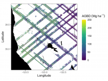
Example subset of aboveground biomass density (AGBD; Mg ha-1) predictions from the GEDI Level-4A footprint version 2.1 product over Northern California, USA, spanning April to July 2019. GEDI footprints are spaced 60m along track and 600m across-track.
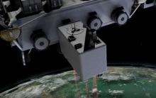
The GEDI instrument onboard the ISS uses three lasers split into eight tracks that fire 242 times per second illuminating a 25-meter footprint of the Earth's surface.
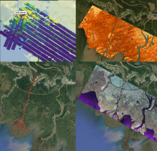
Collage of dataset airborne imagery from AirSWOT, UAVSAR and the ASO lidar instrument provide examination of water level elevation estimates and changes.
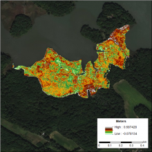
DEM of the Global Change Research Wetland (GCReW) site generated using the LEAN (LiDAR Elevation Correction with NDVI) method. LEAN uses ground measurements of elevation and NDVI in a multivariate linear regression model to estimate vertical bias.
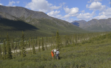
A perspective of one study plot at the forest-tundra ecotone with mature spruce trees transitioning into short-stature trees and low-stature deciduous shrubs.
Terrestrial lidar scanning point cloud data are available for research plots in the Brooks Range of Alaska.
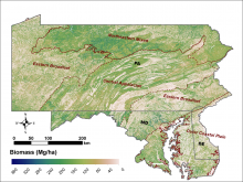
Aboveground biomass (Mg/ha) at 30-m resolution for the tri-state region of Maryland, Pennsylvania, and Delaware in 2011.
LiDAR-derived aboveground biomass, canopy height, and canopy coverage estimates for Maryland, Delaware, and Pennsylvania are now available.

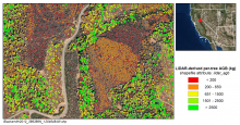
Per-tree aboveground biomass (kg) derived from LiDAR-measured tree heights for the Blacksmith site in 2012.
A new dataset provides LiDAR-derived estimates of aboveground biomass from locations throughout California between 2005 and 2014.
 per-tree derived from LiDAR at the Blacksmith site in 2012")
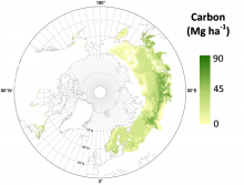
Eurasia boreal forests aboveground carbon estimates (Neigh et al., 2013).
