DAAC Home > Resources > News

News

UAVSAR

UAVSAR P-band polarimetric data from flight lines over Alaska and western Canada, 2017

Submitted by ORNL DAAC Staff on 2021-05-21
Image Media
Image Media
Caption

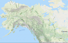
UAVSAR P-band SAR radar swaths over study sites across Alaska, USA, and western Canada for the 2017 ABoVE campaign.

Body
Level 1 polarimetric radar backscattering coefficient, multi-look complex, polarimetrically calibrated, and georeferenced data products for study sites.

Sea Water Elevation Profile and Change from Pre-Delta-X Campaign Datasets

Submitted by ORNL DAAC Staff on 2021-04-05
Image Media
Image Media
Caption

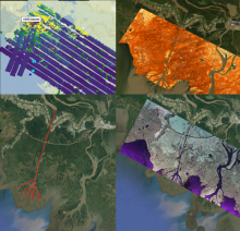
Collage of dataset airborne imagery from AirSWOT, UAVSAR and the ASO lidar instrument provide examination of water level elevation estimates and changes.

Body
Five Pre-Delta-X Airborne datasets recently published provide sea water level profile and change derived from UAVSAR, AirSWOT, and lidar.

Active Layer Thickness Derived from Airborne L- and P-band SAR

Submitted by ORNL DAAC Staff on 2021-03-24
Image Media
Image Media
Caption

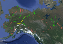
Sites in Version 2 of the Permafrost Dynamics Observatory Project product. Green = data delivered in Version 2. Red = not delivered in Version 2 but will be delivered in future version. Yellow = not processed due to only L-band data being available.

Body
Estimates of seasonal subsidence, ALT, vertical soil moisture profile, and uncertainties at a 30-m resolution for 28 sites across the ABoVE domain are now available.