
The ORNL DAAC recently released this dataset from the Carbon Monitoring Systems (CMS) project by Holmquist, J.R. et al. (2021):
Digital Elevation Models for the Global Change Research Wetland, Maryland, USA, 2016
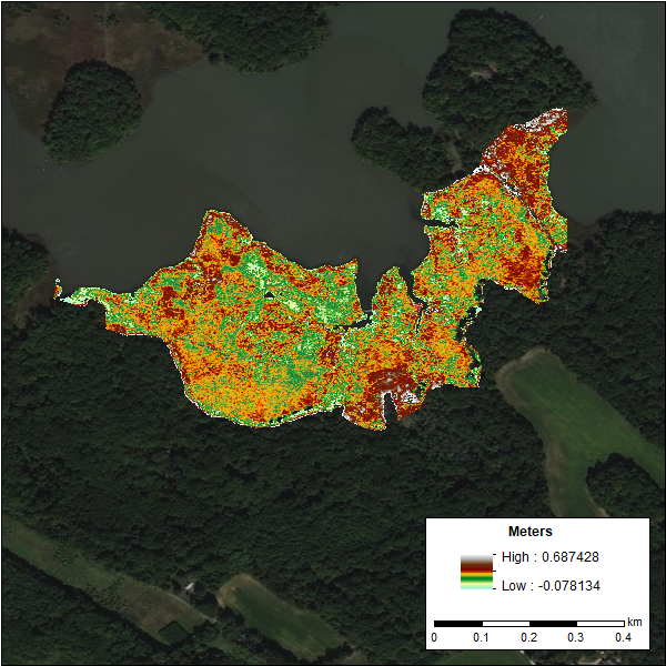
This dataset contains four high-resolution alternative digital elevation models (DEMs) and model performance metrics for the Global Change Research Wetland (GCReW) site on the Rhode River, a tributary of the Chesapeake Bay in Maryland, USA, for the year 2016.
Three DEMs were created using different strategies for correcting positive biases in Light Detection and Ranging (LiDAR)-based DEMs. Methods used included (1) applying a single average offset based on a literature review, (2) using the LiDAR Elevation Correction with NDVI (LEAN)-method, and (3) applying plant community-specific offsets using a local vegetation cover map. An Empirical Bayesian Kriging method which extrapolated between measured ground points generated the fourth DEM. To calibrate the four approaches, the study surveyed the elevation of the entire marsh complex at 20 m x 20 m resolution to document the distribution of elevation relative to tidal datums from a single year.
The GCReW site is one of the most studied tidal wetlands in the world and is the source of many impactful insights on relationships among plant traits, microbial activity, and soil biogeochemical responses to global change factor interactions.
The NASA CMS program is designed to make significant contributions in characterizing, quantifying, understanding, and predicting the evolution of global carbon sources and sinks through improved monitoring of carbon stocks and fluxes. The System uses NASA satellite observations and modeling/analysis capabilities to establish the accuracy, quantitative uncertainties, and utility of products for supporting national and international policy, regulatory, and management activities. CMS data products are designed to inform near-term policy development and planning.
Additional data from Carbon Monitoring System (CMS) project and other relevant links can be found on the ORNL DAAC's CMS Project Page.
Citation: Holmquist, J.R., J. Riera, J.P. Megonigal, L. Shile-Beers, K.J. Buffington, and D.E. Weller. 2021. Digital Elevation Models for the Global Change Research Wetland, Maryland, USA, 2016. ORNL DAAC, Oak Ridge, Tennessee, USA. https://doi.org/10.3334/ORNLDAAC/1793