
The ORNL DAAC recently published the following three Pre-Delta-X Campaign datasets:
Pre-Delta-X: Aboveground Biomass and Vegetation Maps, Wax Lake Delta, LA, USA, 2016
Pre-Delta-X: AVIRIS-derived Total Suspended Solids Maps for MRD, LA, USA, 2015-2016
Pre-Delta-X: L2 AVIRIS-NG Surface Spectral Reflectance across MRD, LA, USA, 2015-2016
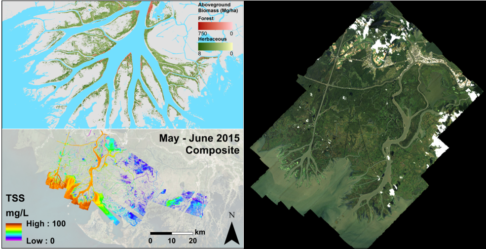
These Pre-Delta-X Demonstration Campaign datasets provide integrative data of the Mississippi River Delta (MRD). High-resolution above ground biomass (AGB) of herbaceous and forest wetland across the Wax Lake Delta is derived from Airborne Visible/Infrared Imaging Spectrometer-Next Generation (AVIRIS-NG) imagery combined with L-band Uninhibited Airborne Vehicle Synthetic Aperture Radar (UAVSAR). Surface spectral reflectance adjusted for Bidirectional Reflectance Disturbance Function (BRDF) effects from AVIRIS-NG imagery data are provided over the Atchafalaya and Terrebonne Basins within the MRD. Total suspended solids (TSS) at the water surface which are estimated from AVIRIS-NG imagery combined with field measurements is also available for the Atchafalaya and Terrebonne Basins.
The Delta-X mission is a 5-year NASA Earth Venture Suborbital-3 mission to study the Mississippi River Delta in the United States, which is growing and sinking in different areas. River deltas and their wetlands are drowning as a result of sea level rise and reduced sediment inputs. The Delta-X mission will determine which parts will survive and continue to grow, and which parts will be lost. Delta-X begins with airborne and in situ data acquisition and carries through data analysis, model integration, and validation to predict the extent and spatial patterns of future deltaic land loss or gain.
All Data products from the 2016 Pre-Delta-X Demonstration Campaign are available now, data collection for the Delta-X Mission began in the Spring of 2021.
Data Citation(s):
Jensen, D.J., M. Simard, R. Twilley, E. Castaneda, and A. McCall. 2021. Pre-Delta-X: Aboveground Biomass and Vegetation Maps, Wax Lake Delta, LA, USA, 2016. ORNL DAAC, Oak Ridge, Tennessee, USA. https://doi.org/10.3334/ORNLDAAC/1821
Jensen, D.J., M. Simard, C.G. Fichot, and T.M. Pavelsky. 2021. Pre-Delta-X: AVIRIS-derived Total Suspended Solids Maps for MRD, LA, USA, 2015-2016. ORNL DAAC, Oak Ridge, Tennessee, USA. https://doi.org/10.3334/ORNLDAAC/1822
Jensen, D.J., D.R. Thompson, I.B. Mccubbin, and M. Simard. 2021. Pre-Delta-X: L2 AVIRIS-NG Surface Spectral Reflectance across MRD, LA, USA, 2015-2016. ORNL DAAC, Oak Ridge, Tennessee, USA. https://doi.org/10.3334/ORNLDAAC/1826