
Learn how to use python tools to work with disparate large-volume data products through this recorded NASA Earthdata Webinar: IceFlow and icepyx: Python tools for Harmonizing Laser Altimetry Datasets in an Open Science Framework .
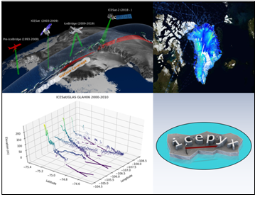
Using laser altimetry to understand the evolution of land and sea ice can be challenging given the large-volume of disparate datasets available from NASA's ICESat, IceBridge, and ICESat-2 missions. Scientists from the National Snow and Ice Data Center (NSIDC) and the University of New Hampshire (UNH) have developed Python-based tools to ease these challenges.
Don't miss this opportunity to learn, through this Earthdata Webinar presented by our colleagues from NSIDC and UNH now.