Body
NASA's AVIRIS-NG instrument detected multiple massive methane plumes in California and much more.

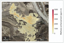
The AVIRIS-NG instrument detected large methane plumes coming from Sunshine Canyon Landfill during its October 2016 overpass. The plumes are shown in a yellow to red gradient, with red representing higher concentrations of methane. Image credit: Cusworth et al. 2020.
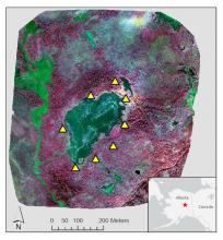
Color infrared image of Big Trail Lake in the Goldstream Creek Valley north of Fairbanks, Alaska. Ground control points (yellow triangles) surround the lake. Image was produced from NIR (red), red (green), and green (blue).
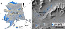
Location of the study area northwest of Fairbanks, AK, USA. The map shows (a) yedoma permafrost distribution and (b) yedoma lakes and terrain of the Goldstream Valley. Data sources include Strauss et al. (2016), Alaska LiDAR Dataset (USGS, 2018), Elevation Datasets of Alaska (DGGS Staff, 2013), and Walter Anthony et al. (2020).
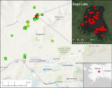
Location of 15 lakes surveyed for methane ebullition hotspots (green points) north of Fairbanks, AK, on October 8, 2014. Inset shows detail of Eagle Lake with locations of 43 hotspots (red points) detected by openings in lake ice.
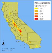
Total annual methane emissions in 2019 from dairy farms in California. These values represent the sum of emissions from enteric fermentation and manure management practices. Units are Gg per square kilometer per year. Source: total_CH4_CA_2019.tif
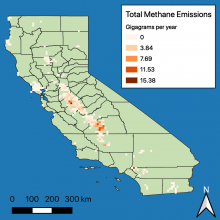
The sum of manure management and enteric fermentation methane emissions (in gigagrams per year) from dairy farms in California.
A new dataset from the North American Carbon Program (NACP) quantifies methane emissions from dairies across California.
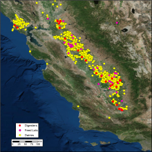
Vista-CA provides locations of methane (CH4) emitting facilities and infrastructure in the State of California. In this figure, the distribution of digesters, feed lots, and dairies across the San Francisco Bay Area and Central Valley are shown.
The Vista-CA dataset provides locations of potential methane (CH4) emitting facilities and infrastructure across the state of California.

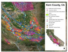
Example of AVIRIS-NG flight lines over the southern San Joaquin Valley, Kern County, CA, in Fall 2016 and the Vista-CA potential methane emitting facilities and infrastructure for the three primary sectors (energy, agriculture, and waste).
Maps of methane plumes were derived from Next-Generation Airborne Visible Infrared Imaging Spectrometer (AVIRIS-NG) flights over California.
