Body
This dataset provides 0.25-degree gridded, global maps of fractional land-use states, transitions, and management practices for the period 0850-2019.

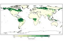
Area fraction of each grid cell of primary lands covered by forests in the year 2000.
17 Goals of the 2030 Sustainable Development Goals of the United Nations.
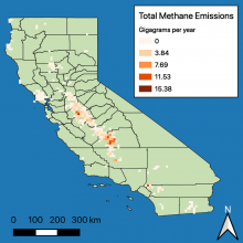
The sum of manure management and enteric fermentation methane emissions (in gigagrams per year) from dairy farms in California.
A new dataset from the North American Carbon Program (NACP) quantifies methane emissions from dairies across California.
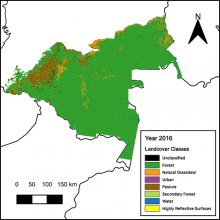
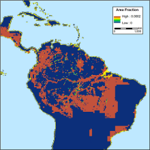
Land cover classification at 30 m resolution for the Colombian Amazon for the year 2016.
New maps of land cover classes for the Colombian Amazon were derived from changes in surface reflectance.
Annual estimates of fractional land use and cover patterns are available for the period 2015 to 2100.
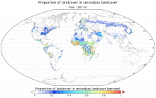
A comprehensive, harmonized data set describing the annual land use patterns of the globe from the year 1500 to the present, and projections to the year 2100, is now available from the ORNL DAAC.
