Body
Sustainable Development Goals Data Pathfinders are now available on NASA's Earthdata Website

17 Goals of the 2030 Sustainable Development Goals of the United Nations.
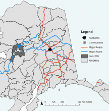
Map of study area communities. GMUs are Game Management Units and GMU21D is highlighted.
Environmental conditions during moose hunting season for 2000-2016 are available for rural Alaska.

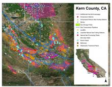
Example of AVIRIS-NG flight lines over the southern San Joaquin Valley, Kern County, CA, in Fall 2016 and the Vista-CA potential methane emitting facilities and infrastructure for the three primary sectors (energy, agriculture, and waste).
Maps of methane plumes were derived from Next-Generation Airborne Visible Infrared Imaging Spectrometer (AVIRIS-NG) flights over California.

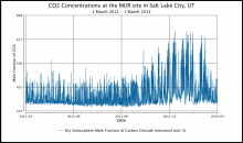
Carbon dioxide concentrations at the MUR site in Salt Lake City, Utah, show a pronounced seasonal pattern of higher CO2 in the winter months.
Hourly urban greenhouse gas measurements are available for cities in the CO2 Urban Synthesis and Analysis (CO2-USA) Data Synthesis Network.

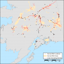
Combined map of subsistence resource use areas of Interior Alaskan communities with (1) points marking harvest effort locations, (2) polygons indicating harvest effort areas, and (3) lines indicating linear harvesting activity.
Maps of the search and harvest areas used by residents of Interior Alaska are available.

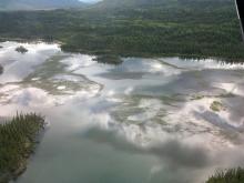
This photo from June 2016 shows the 'extreme' growth of lake grass in a lake near the Tok Community, Alaska.
ABoVE researchers worked with rural communities to document environmental changes that affect access to subsistence resources.
