Body
NASA's AVIRIS-NG instrument detected multiple massive methane plumes in California and much more.

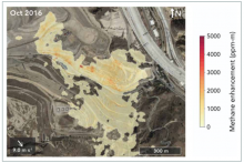
The AVIRIS-NG instrument detected large methane plumes coming from Sunshine Canyon Landfill during its October 2016 overpass. The plumes are shown in a yellow to red gradient, with red representing higher concentrations of methane. Image credit: Cusworth et al. 2020.

17 Goals of the 2030 Sustainable Development Goals of the United Nations.
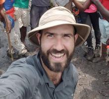
Dr. David Lagomasino uses satellite, airborne, drone, and ground measurements to identify areas of coastal resilience and vulnerability.
Dr. David Lagomasino uses NASA data to study how the Earth's landscape responds to changes caused by natural events and rapid urban expansion.
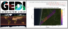
The Find and Use GEDI, You Will—Getting Started with Global Ecosystems Dynamics Investigation (GEDI) Lidar Data webinar will be held on Wednesday, June 24, from 2 to 3 PM EST.
The Land Processes (LP) DAAC will get you started with GEDI data on Wednesday, June 24.
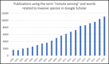
Searching for the term remote sensing and words related to invasive species (invasive, nonnative, exotic, or nonindigenous) in Google Scholar reveals an increasing number of publications each year using these terms.
A new Earthdata article describes how researchers are using remote sensing to map invasive species.